Not Bad for Summer

Not Bad for Summer

🕔14:27, 29.Jul 2022

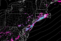
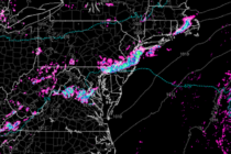
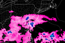
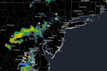
Discussion: The upper-jet will be nearby tonight (Friday) before retreating back to the N for the rest of the weekend and next week. Upper-level flow appears zonal until a weak ridge likely develops by Sunday night to set the stage

Read Full Article
Rain and Storms to Break Heat Wave

Rain and Storms to Break Heat Wave

🕔12:05, 25.Jul 2022

Discussion: Upper levels appear zonal this week as the Bermuda high remains parked. A low tracking through SE Canada, however, will drag a cold front through NJ by Tuesday morning which will bring some relief and break the heat wave

Read Full Article
Heat Wave Continues

Heat Wave Continues

🕔12:14, 22.Jul 2022

Discussion: W/SW upper-level flow continues to tap a very hot air mass in the C US with periodic injections of humid air mass from the Gulf of Mexico. The flow is supported by general Bermuda high circulation. This has New

Read Full Article
Heat Wave Begins

Heat Wave Begins

🕔14:14, 18.Jul 2022

Discussion: Upper-level dynamics suggest a prolonged flow gradually fluctuating between W/SW and SW. No pronounced ridges are modeled for the E US. The flow is almost zonal. But this flow will be tapping a very hot region in the C

Read Full Article
Summery Conditions Continue

Summery Conditions Continue

🕔15:25, 14.Jul 2022

Discussion: Temperatures are currently maxing today near-90 along the I-95 corridor. 80s for elevations and most coastal regions while the immediate ECNJ/SENJ coast sits in the 70s due to sea breeze dynamics. The SBF sparked a few downpours and thunder

Read Full Article
Thunderstorms Approaching New Jersey

Thunderstorms Approaching New Jersey

🕔14:27, 12.Jul 2022

Discussion: A very progressive trough is currently aligned through SouthEast Canada and the NorthEast US. A surface low is riding the front of the trough today just to the N of Maine. A frontal boundary (cold front) is attached to

Read Full Article
Watching Tuesday PM for Storms

Watching Tuesday PM for Storms

🕔14:40, 11.Jul 2022

Discussion: Today started the week off with a warm but pleasant feel with temps in the 80s and dews near or just under 60. Humidity will increase overnight (tonight) and into tomorrow (Tuesday) as warm sector SW flow builds ahead

Read Full Article
Tracking Saturday’s Rain

Tracking Saturday’s Rain

🕔12:03, 8.Jul 2022

Discussion: A very progressive trough will swing through the NorthEast US this weekend. At the same time, a disturbance will eject off the top of the C US ridge and track along a boundary through the S Mid-Atlantic US on

Read Full Article
Rain, possibly storms, approaching SNJ

Rain, possibly storms, approaching SNJ

🕔14:33, 5.Jul 2022

Discussion: For this week, we’ll have mostly NW upper-level flow coming off the ridge that is currently establishing over the C US. The NW flow will be the result of the top of the ridge combining a split flow pattern

Read Full Article