The New Roswell? Everything we know about the NJ Drones
Ok, so I’m not a conspiracy theorist, but last night I actually saw one. I took the trash out and when I got to the dark corner of my house, I noticed an aerial vehicle moving very fast to my


Ok, so I’m not a conspiracy theorist, but last night I actually saw one. I took the trash out and when I got to the dark corner of my house, I noticed an aerial vehicle moving very fast to my
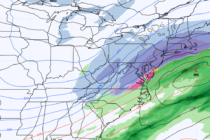
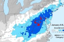
Discussion: Last night’s storm system was certainly unique for January. Many are still dealing with some back bay, creek, stream, and river flooding aftermath today but this should subside by tonight/tomorrow. Winds last night were about 80% of what they
Lets travel back in time and check out some major snow storms that have affected New Jersey in the past. But first, lets talk about the unique geological and climatological features that have contributed to these major New Jersey snow
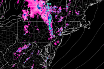
Discussion: A quick glance at the radar indicated that the storm front is knocking on NWNJ’s door. A few smaller cells have formed today for NJ, ahead of this storm front, but were non-severe and ended up fading out. The

Today and tomorrow should be the last few days of warmer temperatures and elevated humidity. On Sunday we’ll have a dry cold frontal passage which will provide some relief. Beyond that is interesting. After the front moves through on Sunday,

High pressure will continue to dominate the region but temperatures and humidity should make it feel more like July than September. Let’s break each day down: Monday high temperatures should range from 85-90 with interior regions having the best chance

A strong ridge of re-enforced high pressure should continue building over the E. US. This will bring above-average temperatures to the entire mid-Atlantic region for the first third-to-half of September. I’ll be releasing the long-range September outlook (powered by WeatherTrends360)

Erika has remained extremely weak and has been downgraded to just a tropical depression. This is due to land interaction and the stronger shear environment of the northern Caribbean. Because of this, she has drifted westward considerably before making the

Total high pressure domination for a beautiful late-summer weekend. Let’s break it down… Friday high temperatures should reach the upper-70s and lower-80s statewide. Skies should be mostly sunny with a pleasant dry and crisp feel. Winds should be light out

Tropical Storm Erika remains weak in the NE Caribbean Sea. She will battle a strong upper-level wind shear environment over the next 24-36 hours as well as possibly the higher elevations of Hispaniola. This should keep her weak despite healthy

LOCAL FORECAST | INTERACTIVE RADAR | LATEST NJ WEATHER ALERTS | WEDDING FORECAST| PRIVACY POLICY
© Copyright 2026 Weather NJ LLC. All Rights Reserved.
Some information that can be found on our website is provided by a private weather station and is not an officially recognized station for weather reporting. Though we always strive to achieve accurate reporting for our own use, it is important that you do NOT depend on the data provided here for any purpose.


