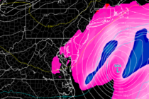
Back to homepage

Feature POST on Homepage

More Volatile Temperature Flops

More Volatile Temperature Flops

🕔21:01, 20.Nov 2017

Discussion: 250mb analysis of the jet stream indicates a general zonal flow across the US for the near future. Tuesday and Wednesday appear rather mild with SW return flow (from the departing high) dominating the pattern. We should then see

Read Full Article
Listen to the wind blow, watch the sun rise

Listen to the wind blow, watch the sun rise

🕔16:19, 18.Nov 2017

Most, if not all, of NJ should see a mild and breezy (out of the SW) start to the night. Some might experience a few early-AM boomers embedded within the short-duration period of heavy rainfall. By the time the sun

Read Full Article
Unsettled Conditions Expected (Nov 17-19)

Unsettled Conditions Expected (Nov 17-19)

🕔21:49, 16.Nov 2017

Discussion: After a colder Thursday night, an area of high pressure should track from the Ohio Valley area through OBX towards Bermuda. This should keep conditions mild and dry through about Saturday morning. We’re then looking at classic Norwegian Cyclone

Read Full Article
Cold Start to the Week (Nov 13-17)

Cold Start to the Week (Nov 13-17)

🕔20:49, 12.Nov 2017

Discussion: Temperatures this week should start below-average and finish near-average heading into the weekend. Overall, upper-level height anomalies are positive through much of the US. The only area of disturbance is currently moving through our region and is expected to

Read Full Article
Cold Conditions Expected (Nov 10-12)

Cold Conditions Expected (Nov 10-12)

🕔20:16, 9.Nov 2017

Discussion: A shallow trough will bring a transient period of well-below average temperatures to the region tonight through Sunday morning. The Arctic shot should peak for New Jersey Saturday AM with moderation expected by Sunday afternoon. Friday and Saturday night

Read Full Article
Colder Transition Expected (Nov 6-10)

Colder Transition Expected (Nov 6-10)

🕔11:52, 6.Nov 2017

Discussion: The upper levels should gradually transition from positive 500mb height anomalies to negative between now and Wednesday. NNJ elevations (mostly NWNJ) has the chance to see their first frozen precipitation of the year Tuesday evening through early Wednesday morning.

Read Full Article
Mild Weather Expected (Nov 3-5)

Mild Weather Expected (Nov 3-5)

🕔09:35, 3.Nov 2017

Discussion: The upper levels look to feature above-average height anomalies. This tells me the overall temperature profile should remain on the milder side for this time of year. Aside from an isolated Friday afternoon shower and raw/damp/misty conditions Sunday, the

Read Full Article
A look through November with WT360

A look through November with WT360

🕔13:36, 2.Nov 2017

It’s time to harness the WeatherTrends360 proprietary weather algorithms to see how November 2017 should play out. But first lets break New Jersey into proper climatological regions. We have the higher elevations of NNJ/NWNJ, the interior coastal plain (SWNJ through CNJ and into NENJ –

Read Full Article
Cooler Start. Mild Finish (Oct 30-Nov 3)

Cooler Start. Mild Finish (Oct 30-Nov 3)

🕔10:31, 30.Oct 2017

Discussion: The storm has retreated northward into Canada after phasing and bringing significant rainfall and moderate winds to portions of New Jersey and especially New England. Behind this system will be a relatively cooler/cold air mass for the first half

Read Full Article
Oct 28: Rainstorm Approaching

Oct 28: Rainstorm Approaching

🕔09:59, 28.Oct 2017

Discussion: Typhoon Lan has moved through the west Pacific Ocean into the Bering Sea. This has produced strong ridging in the Gulf of Alaska/W US area (+PNA) which has symbiotically produced a trough for the E US. The trough is expected

Read Full Article