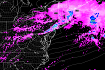
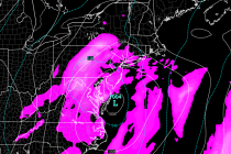
Back to homepage

Feature POST on Homepage

Jan 31: Winter Storm Update – 2nd Call Map

Jan 31: Winter Storm Update – 2nd Call Map

🕔19:18, 31.Jan 2015

Model guidance trended northward last night and today. Instead of a weaker ~1004mb low passing over the VA/NC border, a ~995mb is modeled to pass over the Delmarva Peninsula and SNJ. The low is simply northward because it’s slightly amped

Read Full Article
Jan 30: Sunday Night-Monday Winter Storm Update

Jan 30: Sunday Night-Monday Winter Storm Update

🕔20:38, 30.Jan 2015

Models have trended northward to the point where New Jersey is no longer on the northern fringe of precipitation. The latest guidance suggests NNJ seeing the snowiest solution, CNJ still seeing significant snowfall, and SNJ seeing light snowfall with mixing.

Read Full Article
Jan 29: Snow Storm Detected!

Jan 29: Snow Storm Detected!

🕔21:40, 29.Jan 2015

Model guidance is in pretty strong agreement that a snow storm will impact New Jersey in the Sunday evening-Monday evening time period. With this system an overall weak low pressure disturbance will pass to the south of NJ…somewhere near the

Read Full Article
Cold Weekend Expected with Wintry End (Jan 30-Feb 1)

Cold Weekend Expected with Wintry End (Jan 30-Feb 1)

🕔17:04, 29.Jan 2015

Once the clipper clears out tomorrow, below-average temperatures will move in behind and dominate the entire weekend. Friday and Saturday look dry but a snow storm could move in Sunday night and impact the region into Tuesday morning. Let’s look

Read Full Article
Jan 28: Light Snow Detected + Late-Weekend Potential

Jan 28: Light Snow Detected + Late-Weekend Potential

🕔21:08, 28.Jan 2015

A clipper will bring light snow throughout our region as it passes through the northern part of our coverage area tomorrow night into Friday morning. It doesn’t look like a super cold clipper with typical 20+:1 snow ratios (inches of

Read Full Article
How Every Meteorologist (Including Myself) Got it WRONG!

How Every Meteorologist (Including Myself) Got it WRONG!

🕔09:19, 27.Jan 2015

The Worst Storm in our Lifetime it was being called. Preemptive State of Emergencies. Statewide Travel Bans – Even NYC closed its bridges and tunnels for the first time in recent memory. So how could the entire weather community get

Read Full Article
Jan 24: Snow Storm Detected!

Jan 24: Snow Storm Detected!

🕔17:06, 24.Jan 2015

Up until today, models have been advertising another clipper for Monday with just light accumulations from a few passing showers. Today’s guidance has trended towards a possible major snow storm in the Sunday night-Tuesday time-frame. Here’s the details… First, I’d

Read Full Article
Jan 23: Final Call on Weekend Winter Storm

Jan 23: Final Call on Weekend Winter Storm

🕔11:37, 23.Jan 2015

A deepening low pressure disturbance will take a classic “benchmark 40N/70W” track between now and Saturday. This will bring up a decent amount of moisture from the Gulf of Mexico as well as throw in a lot of moisture from the Atlantic

Read Full Article
Jan 22: Watching Monday for Snow

Jan 22: Watching Monday for Snow

🕔18:26, 22.Jan 2015

Regardless of how the snow/rain line plays out tomorrow night through Saturday, the associated low will be powerful. Guidance is unanimous on a sub 980mb low once it begins impacting New England on Saturday night-Sunday. This will pull very cold

Read Full Article
Jan 22: Weekend Winter Storm Update

Jan 22: Weekend Winter Storm Update

🕔16:00, 22.Jan 2015

A deepening low pressure disturbance will take a classic “benchmark 40N/70W” track between tomorrow and Saturday. This will bring up a a decent amount of moisture from the Gulf of Mexico as well as throw in a lot of moisture from

Read Full Article