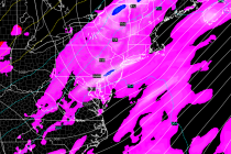
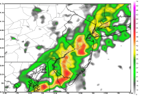
Back to homepage

Feature POST on Homepage

Jan 21: Weekend Snow Storm a GO!

Jan 21: Weekend Snow Storm a GO!

🕔14:26, 21.Jan 2015

Model guidance continues to advertise a major coastal low pressure system in the ideal “Benchmark 40N/70W” track/location this weekend. This would mean significant to major snowfall throughout most of New Jersey and surrounding big cities this Saturday. Let’s go right

Read Full Article
Jan 20: Final Call Map for Wednesday Snow

Jan 20: Final Call Map for Wednesday Snow

🕔20:30, 20.Jan 2015

Here’s my final call for tomorrow’s snow.. My rationale after reviewing the latest guidance is mostly based on a connection between the northern low and the coastal low (both weak). The darker blue area should see the most precipitation from

Read Full Article
Jan 20: Major Storm Threats for the Northeast

Jan 20: Major Storm Threats for the Northeast

🕔14:56, 20.Jan 2015

If it winds up that we have not one but 2 major storms to deal with only a couple of days apart it would be the first time that I can remember ever seeing something like this. In fact I

Read Full Article
Jan 20: Major Snow Storm Signal for Weekend

Jan 20: Major Snow Storm Signal for Weekend

🕔11:30, 20.Jan 2015

I’ve been watching this thing on guidance since last week and it’s time to start talking about it. A strong piece of energy is going to dig southward from Colorado down into Texas, pick up a bunch of moisture, and

Read Full Article
Jan 19: Wednesday Snow Map

Jan 19: Wednesday Snow Map

🕔18:49, 19.Jan 2015

After reviewing the latest model guidance and taking into consideration the current synoptic pattern, I’m prepared to issue the following snow map for this Wednesday’s clipper snow event: The general idea here is that weak low pressure will dive into

Read Full Article
Watching Mid-week Snow this Week (Jan 19-23)

Watching Mid-week Snow this Week (Jan 19-23)

🕔13:58, 19.Jan 2015

Today, tomorrow, most of Thursday and Friday should feature seasonably average dry weather. A light snow event could impact the general region on Wednesday and linger into early Thursday AM. Let’s break down each day: Monday should reach the upper 30s

Read Full Article
Jan 18: Clipper Snow Detected

Jan 18: Clipper Snow Detected

🕔21:42, 18.Jan 2015

Temperatures will stay cold for the next several days as a weak low pressure disturbance dives into the region from the W/NW…aka a clipper. Clippers traditionally surprise people with a few quick inches. Snow ratios tend to be higher from

Read Full Article
Jan 17: Coastal Rain Storm Approaching!

Jan 17: Coastal Rain Storm Approaching!

🕔10:41, 17.Jan 2015

A low pressure disturbance will form close to the mid-Atlantic coast Sunday morning and track into New England. This should bring a period of moderate-to-heavy rain to New Jersey from Sunday morning through early Monday AM. The coast is modeled to see

Read Full Article
Mixed Weekend Weather Expected (Jan 16-18)

Mixed Weekend Weather Expected (Jan 16-18)

🕔00:00, 16.Jan 2015

The first part of the weekend looks dry and sunny but Sunday could feature some rain and wind. Here’s what to expect: Friday should reach the mid-30s to lower 40s for high temperatures (from NWNJ to SENJ). Winds should be

Read Full Article
Jan 15: Coastal Rain Storm Detected!

Jan 15: Coastal Rain Storm Detected!

🕔11:57, 15.Jan 2015

Low pressure will form off the coast of Virginia Sunday morning and track to the N/NE bringing possibly heavy rain and moderate wind to New Jersey from Sunday morning through early Monday AM. Expected rainfall amounts range from .25 to

Read Full Article