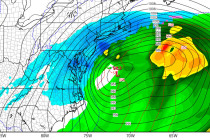
Back to homepage

Feature POST on Homepage

Jan 9: Monday Storm Update!

Jan 9: Monday Storm Update!

🕔19:26, 9.Jan 2015

There’s enough model support, in my opinion, to start getting ready for a winter event to start the week as early as late Sunday night. In tracking the evolution of next week’s weather pattern, here’s where we’re at right now.

Read Full Article
Cold and Dry Weekend Expected (Jan 9-11)

Cold and Dry Weekend Expected (Jan 9-11)

🕔11:40, 9.Jan 2015

High pressure, currently dropping out of Canada, will have full control of New Jersey this weekend. It will move through the Midwest US and pass just to our S into the Atlantic Ocean. This means generally dry conditions but not

Read Full Article
Jan 8: Clipper Approaching and Update on Next Week

Jan 8: Clipper Approaching and Update on Next Week

🕔21:10, 8.Jan 2015

Another clipper is approaching and next week’s winter storm possibility is still on the table. Let go right into detail. Current radar observations indicate snow showers and squalls moving through Ohio and approaching western PA. That puts it on the

Read Full Article
Jan 7: Friday AM Snow Detected…and About Next Week

Jan 7: Friday AM Snow Detected…and About Next Week

🕔19:03, 7.Jan 2015

Before we talk about the snow potential for next week we need to first look at this Friday. Another clipper system will be passing through—this time to our north. Short-range model guidance is indicating a lake-enhanced squall passing through New

Read Full Article
Jan 6: Arctic Cold Air Approaching!

Jan 6: Arctic Cold Air Approaching!

🕔14:59, 6.Jan 2015

Now that the clipper has moved through, very cold Arctic air will move in behind and keep temperatures well below-average starting tonight and heading into the weekend. The coldest moment of this Arctic wave appears to be early Thursday AM

Read Full Article
Snow Map for Tuesday

Snow Map for Tuesday

🕔18:48, 5.Jan 2015

A clipper system is riding the Arctic front heading straight for the mid-Atlantic US. This means light powdery accumulating snowfall tomorrow starting as early as sunrise in WNJ and as late as 9AM in ENJ. Clippers are generally fast movers

Read Full Article
Another Cold Week Expected (Jan 5-9)

Another Cold Week Expected (Jan 5-9)

🕔11:14, 5.Jan 2015

“Listen to the wind blow…watch the sunrise” – The Chain, Fleetwood Mac …That’s the best way I can describe the two cold fronts moving through New Jersey today. One associated with the low that moved through yesterday/overnight and the other moving through

Read Full Article
Jan 4: Light Snow Storm and Arctic Outbreak Detected!

Jan 4: Light Snow Storm and Arctic Outbreak Detected!

🕔09:47, 4.Jan 2015

Over the last few days, I’ve been tracking what’s known as an Alberta Clipper that’s modeled to bring light snow to New Jersey this ~Tuesday. We’re within 72 hours of the event now with strong model guidance support so it

Read Full Article
Wet Weekend Expected (Jan 2-4)

Wet Weekend Expected (Jan 2-4)

🕔08:21, 2.Jan 2015

The colder air mass that has dominated our region this week will temporarily retreat, allowing a low pressure system to cut into the eastern Great Lakes region. Precipitation could start wintry on Saturday for areas away from the ocean, especially

Read Full Article
Dec 31: Weekend Storm Update

Dec 31: Weekend Storm Update

🕔19:39, 31.Dec 2014

First, on behalf of Weather NJ, I’d like to wish you all a safe and happy new year! To the people who have been standing outside in NYC and will continue to stand outside through midnight, I don’t need to

Read Full Article