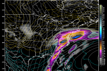
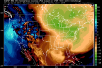
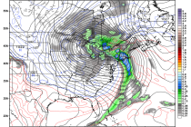
Dec 2: Tuesday NJ Forecast Video
Watch this Weather Forecast Video covering the weather associated with our region, so you can start your day off right, by knowing what weather awaits you when you walk out your front door! Weather NJ
High pressure is currently forcing a cold front southeastward through the region with some precipitation. The cold front will eventually stop and backtrack northwestward as a warm front through tomorrow evening/Wednesday morning. Like tonight, there should be precipitation along that boundary as
Nothing in the weather world among weather freaks, geeks and snow weenies gets them more passionate than the winter and a good old fashioned snowstorm. Now I know for most of humankind who are among the sane nothing probably gets
Watch this Weather Forecast Video covering the weather associated with our region, so you can start your day off right, by knowing what weather awaits you when you walk out your front door! Weather NJ
With the exception of Tuesday, we’re looking at a seasonably average week for December. Some would even call it mild. Higher elevations of NW New Jersey could see wintry precipitation Tuesday night into Wednesday morning. It looks like rain for all lower elevations.
It’s time to harness the true power of WeatherTrend360’s proprietary algorithms again as we head into December. First lets break New Jersey into proper climatological regions. We have the upper elevations of NWNJ, the interior coastal plain (SWNJ through CNJ and into NENJ), and
Hopefully everyone had a great Thanksgiving! The weekend should start out cold and then moderate into next week towards seasonably average, if not slightly above, temperatures. Lets look at each day: Friday will struggle to reach 40 statewide with a
Here’s my final snow map for tomorrow. A coastal winter storm will impact most of the mid-Atlantic and Northeast US region the day before Thanksgiving. It’s now time to abandon model guidance and now-cast the system based on current observations.
A winter storm is still expected for this Wednesday which will impact millions of people traveling for the Thanksgiving Holiday. Most model guidance is currently suggesting a coastal low pressure track near or just inside the benchmark (40N/70W). There is
A very powerful low pressure disturbance is currently over the Great Lakes region which is drawing up warmth and moisture from the south. That will result in a very mild start to the week. A secondary coastal low pressure system