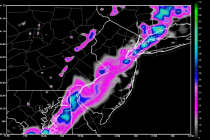
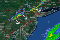
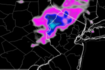
Back to homepage

Feature POST on Homepage

Summery Week Expected (Aug 25-29)

Summery Week Expected (Aug 25-29)

🕔21:06, 24.Aug 2014

Lots of high pressure will be moving throughout the region this week. We’re looking pretty good to start while flow remains out of the east. At some point the winds will switch to the SW which will bring humidity up

Read Full Article
Aug 24: Cristobal? More like Misstobal!

Aug 24: Cristobal? More like Misstobal!

🕔11:37, 24.Aug 2014

Short range guidance has converged on an out to sea miss solution for Cristobal. This means that the NE upper-level trough will have more influence over its track than the high-pressure S ridge. Currently Cristobal is heading NW, just NW

Read Full Article
Aug 23: Important Tropical Update!

Aug 23: Important Tropical Update!

🕔11:54, 23.Aug 2014

Tropical development continues to be slow in the Dominican Republic/Puerto Rico region. Higher elevations of the W. Greater Antilles have taken their toll on the system currently being investigated (Invest 96L). Intensification, however, is expected today-tonight as it moves into

Read Full Article
Aug 22: Watching the Tropics Closely

Aug 22: Watching the Tropics Closely

🕔11:28, 22.Aug 2014

Tropical development near the Leeward Islands of the Lesser Antilles has been hindered and stunted by it’s surrounding environment. It will likely remain disorganized as it passes over/just to the North of the Greater Antilles. It will then turn northwards

Read Full Article
Cool but Dry Weekend Expected (Aug 22-24)

Cool but Dry Weekend Expected (Aug 22-24)

🕔19:54, 21.Aug 2014

Tomorrow we’ll deal with another unsettled day but the threat of rain will subside by Saturday morning if not tomorrow night. Lets break it down by day: Friday will again be unsettled with variable clouds and rain possible at any

Read Full Article
Aug 21: Unsettled Weather Expected Today

Aug 21: Unsettled Weather Expected Today

🕔09:52, 21.Aug 2014

Good morning! The onshore flow will persist today with unsettled conditions across the mid-Atlantic US region. That means you should expect variable clouds, a little bit of sun and possible rain showers that can happen anytime. This evening and through

Read Full Article
Aug 20: Tropical Activity Detected!

Aug 20: Tropical Activity Detected!

🕔19:07, 20.Aug 2014

Tropical development is expected just east of the Windward Islands of the Lesser Antilles. At this point it’s fairly certain that this will move behind the Leeward Islands and into the Eastern Caribbean Sea under the name Cristobal (if Tropical

Read Full Article
Your Weekly Forecast – Onshore Flow! (Aug 18-22)

Your Weekly Forecast – Onshore Flow! (Aug 18-22)

🕔19:20, 17.Aug 2014

Today looks decent but Tuesday and into the rest of the week will be heavily influenced by onshore flow yielding cooler temperatures, humid air, variable clouds, and possibly scattered rain/storms. On a synoptic scale, an upper-level low pressure system is

Read Full Article
Mixed Weekend Weather Expected (Aug 15-17)

Mixed Weekend Weather Expected (Aug 15-17)

🕔07:17, 15.Aug 2014

High pressure will be in control of the region through at least Saturday night. This will keep it cool and comfortable with little to no chance of rain. Sunday, however, will likely see impacts from a low pressure disturbance moving

Read Full Article
Aug 12: Wet Night Expected

Aug 12: Wet Night Expected

🕔19:40, 12.Aug 2014

Widespread heavy rainfall has already fallen over portions of southern New Jersey. Northern New Jersey is up next as precipitation pushes north along the occluded frontal boundary. Occluded simply means that the cold front has caught the warm front just

Read Full Article