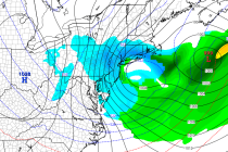
Back to homepage

Latest NJ Weather Alerts

Jan 6: Arctic Cold Air Approaching!

Jan 6: Arctic Cold Air Approaching!

🕔14:59, 6.Jan 2015

Now that the clipper has moved through, very cold Arctic air will move in behind and keep temperatures well below-average starting tonight and heading into the weekend. The coldest moment of this Arctic wave appears to be early Thursday AM

Read Full Article
Snow Map for Tuesday

Snow Map for Tuesday

🕔18:48, 5.Jan 2015

A clipper system is riding the Arctic front heading straight for the mid-Atlantic US. This means light powdery accumulating snowfall tomorrow starting as early as sunrise in WNJ and as late as 9AM in ENJ. Clippers are generally fast movers

Read Full Article
Another Cold Week Expected (Jan 5-9)

Another Cold Week Expected (Jan 5-9)

🕔11:14, 5.Jan 2015

“Listen to the wind blow…watch the sunrise” – The Chain, Fleetwood Mac …That’s the best way I can describe the two cold fronts moving through New Jersey today. One associated with the low that moved through yesterday/overnight and the other moving through

Read Full Article
Jan 4: Light Snow Storm and Arctic Outbreak Detected!

Jan 4: Light Snow Storm and Arctic Outbreak Detected!

🕔09:47, 4.Jan 2015

Over the last few days, I’ve been tracking what’s known as an Alberta Clipper that’s modeled to bring light snow to New Jersey this ~Tuesday. We’re within 72 hours of the event now with strong model guidance support so it

Read Full Article
Wet Weekend Expected (Jan 2-4)

Wet Weekend Expected (Jan 2-4)

🕔08:21, 2.Jan 2015

The colder air mass that has dominated our region this week will temporarily retreat, allowing a low pressure system to cut into the eastern Great Lakes region. Precipitation could start wintry on Saturday for areas away from the ocean, especially

Read Full Article
Dec 31: Weekend Storm Update

Dec 31: Weekend Storm Update

🕔19:39, 31.Dec 2014

First, on behalf of Weather NJ, I’d like to wish you all a safe and happy new year! To the people who have been standing outside in NYC and will continue to stand outside through midnight, I don’t need to

Read Full Article
Dec 31: Forecast Video Discussion

Dec 31: Forecast Video Discussion

🕔11:06, 31.Dec 2014

Meteorologist and Weather NJ contributor Bobby Martrich of Eastern PA Weather Authority has your Wednesday, New Years Eve video outlook. Jonathan CarrJonathan Carr (JC) is the founder and sole operator of Weather NJ, New Jersey’s largest independent weather reporting agency.

Read Full Article
Dec 30: Weekend Storm Update

Dec 30: Weekend Storm Update

🕔18:44, 30.Dec 2014

After reviewing the latest model guidance, there is a general consensus that low pressure will form in the southern US this weekend and take a track known as a Great Lakes Cutter (GLC)—possibly bringing snow, sleet, and/or freezing rain to

Read Full Article
Dec 30: Forecast Video Discussion

Dec 30: Forecast Video Discussion

🕔10:47, 30.Dec 2014

Meteorologist and Weather NJ contributor Bobby Martrich of Eastern PA Weather Authority has your Tuesday video outlook. Weather NJ

Read Full Article
Dec 29: Arctic Air Approaching!

Dec 29: Arctic Air Approaching!

🕔11:03, 29.Dec 2014

As referenced last week, Arctic high pressure is dropping out of Canada into the US over Montana. Associated anti-cyclonic flow is pushing an Arctic cold front through the eastern US. Starting tomorrow and heading into the weekend, you’ll see the

Read Full Article