Feb 2: Monitoring Thursday and Beyond
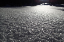
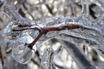
Road crews have been doing an excellent job given the amount of icing that occurred yesterday and overnight. There are still areas of ice, mostly north of I-195, but now that the sun has been up for a few hours


Road crews have been doing an excellent job given the amount of icing that occurred yesterday and overnight. There are still areas of ice, mostly north of I-195, but now that the sun has been up for a few hours
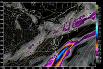
Low pressure is currently transferring from EPA to the southern Jersey coast. As the entire systems pulls away to the E/NE, temperatures are going to rapidly crash from NW to SE between now and this evening. This will present a
Let’s break down each color region in English: The darker blue area furthest to the north will likely see an all snow solution with very little mixing and only on it’s southern border “if” any occurs. Otherwise, 6-12 inches of
Model guidance trended northward last night and today. Instead of a weaker ~1004mb low passing over the VA/NC border, a ~995mb is modeled to pass over the Delmarva Peninsula and SNJ. The low is simply northward because it’s slightly amped
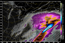
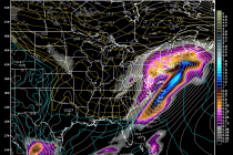
Models have trended northward to the point where New Jersey is no longer on the northern fringe of precipitation. The latest guidance suggests NNJ seeing the snowiest solution, CNJ still seeing significant snowfall, and SNJ seeing light snowfall with mixing.
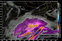
Model guidance is in pretty strong agreement that a snow storm will impact New Jersey in the Sunday evening-Monday evening time period. With this system an overall weak low pressure disturbance will pass to the south of NJ…somewhere near the

Once the clipper clears out tomorrow, below-average temperatures will move in behind and dominate the entire weekend. Friday and Saturday look dry but a snow storm could move in Sunday night and impact the region into Tuesday morning. Let’s look
A clipper will bring light snow throughout our region as it passes through the northern part of our coverage area tomorrow night into Friday morning. It doesn’t look like a super cold clipper with typical 20+:1 snow ratios (inches of
The Worst Storm in our Lifetime it was being called. Preemptive State of Emergencies. Statewide Travel Bans – Even NYC closed its bridges and tunnels for the first time in recent memory. So how could the entire weather community get
The clipper is already approaching the Ohio Valley and is looking strong! It will transfer to the OBX area, move towards the benchmark (40N/70W) and bomb out to a very strong low pressure system (sub 980mb). It might actually retrograde/stall

LOCAL FORECAST | INTERACTIVE RADAR | LATEST NJ WEATHER ALERTS | WEDDING FORECAST| PRIVACY POLICY
© Copyright 2026 Weather NJ LLC. All Rights Reserved.
Some information that can be found on our website is provided by a private weather station and is not an officially recognized station for weather reporting. Though we always strive to achieve accurate reporting for our own use, it is important that you do NOT depend on the data provided here for any purpose.


