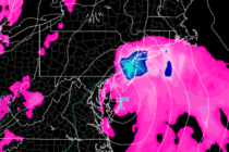
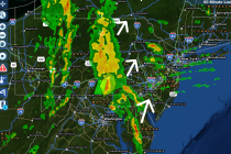
Heat Wave Continues
Discussion: W/SW upper-level flow continues to tap a very hot air mass in the C US with periodic injections of humid air mass from the Gulf of Mexico. The flow is supported by general Bermuda high circulation. This has New
Discussion: A low pressure disturbance is currently forming on the coastal border of North and South Carolina. We’re not talking about a powerful system but organized enough to bring nuisance-to-mildly-disruptive conditions to the E US coast (OBX to NYC) between
Discussion: The upper-level jet should remain loose and disorganized over the E US through about Thursday. We’ll then see an upper-level jet streak overhead for Friday-Saturday. Aside from a transient trough nose swinging through in that same period, much of
Weather NJ is proud and honored, at the request of Southern Ocean County Chamber of Commerce, to provide a special event forecast for the 30th annual LBI Chowderfest next weekend (Saturday and Sunday, September 29-30)! This family fun festival features live music, craft
Another unsettled weekend is on tap thanks to two passing fronts. Let’s break it down: Friday (May 13 – eww!) high temperatures should reach the mid-to-upper 60s. 70 is not off the table. Rain and thunderstorms are possible, especially during
You and your family are invited to participate and honor the legacy of one of New Jersey’s most beloved coaches of all time by attending the Third Annual “Jack DiSalvo” Charity Baseball Game! This year’s event will feature a FREE Bouncy House and Unlimited
A coastal low pressure disturbance will pass by to our SE and track from just off OBX to the E/NE out to sea. During the brief period, while the disturbance closest to us, some very light onshore flow and raw
Several bands containing heavy rainfall and thunderstorms have formed to our W/SW and are approaching New Jersey. The cold front is just arriving at the Pittsburgh, PA longitude and will continue to advance towards New Jersey overnight and into the
The warmer temperatures as of late should fall back within seasonably average parameters for mid-to-late August as we head into the weekend. Conditions, however, should remain unsettled through Monday with widespread rainfall likely at times. Short-range model guidance indicates that the heaviest
Welcome to my print store. Initial prices are considered “absolute blowout launch” and will be re-evaluated after 30 days of sales. Jonathan CarrJonathan Carr (JC) is the founder and sole operator of Weather NJ, New Jersey’s largest independent weather reporting agency. Since