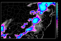
July 23: Storms about to hit New Jersey
Thunderstorms have begun moving into NWNJ but are looking stronger for points south. A decent amount of storm energy is currently heading towards the Philadelphia region. The actual line of precipitation is actually quite thin. That means a short period