Colder and Dry (Nov 1-3)

Colder and Dry (Nov 1-3)

🕔15:35, 31.Oct 2019

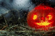
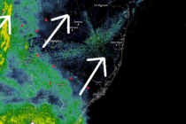
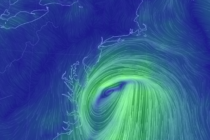
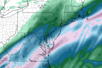
Discussion: First a quick update on this evening. The lull in precipitation is still expected to last through trick or treat hours tonight. Areas along and NW of the turnpike have the best chance for a passing shower but nothing

Read Full Article
Halloween Trick or Treat Forecast

Halloween Trick or Treat Forecast

🕔16:10, 30.Oct 2019

Discussion: I wish to extend great empathy for parents and guardians worried about their children tomorrow night during primary trick or treat hours. There are some articles out there calling for Book of Genesis rainfall and Wizard of Oz winds.

Read Full Article
Unsettled Conditions (Oct 28-Nov 1)

Unsettled Conditions (Oct 28-Nov 1)

🕔21:31, 27.Oct 2019

Discussion: Upper-level ridging should dominate the pattern through Wednesday possibly even some of Thursday. At the surface this means high pressure but not necessarily clear. We might see some raw misty onshore flow conditions in the Tuesday-Wednesday period. Monday-Thursday looks

Read Full Article
Great Start Wet Finish (Oct 25-27)

Great Start Wet Finish (Oct 25-27)

🕔12:03, 24.Oct 2019

Discussion: upper-level ridging should dominate the first half of the weekend pattern with high pressure at the surface. This should keep us mostly dry from now through Saturday night. A weak shortwave should then track through the Great Lakes (well

Read Full Article
Operation Halloween Forecast – This Weekend!

Operation Halloween Forecast – This Weekend!

🕔16:45, 23.Oct 2019

It is our great honor to provide a Weather NJ Special Event Forecast for the 8th annual 2019 Operation Halloween charity event this weekend! WEATHER NJ SPECIAL EVENT FORECAST Friday (Oct 25) daytime high temperatures should reach into the upper-60s

Read Full Article
Mixed Conditions (Oct 22-25)

Mixed Conditions (Oct 22-25)

🕔19:58, 21.Oct 2019

Discussion: Nothing crazy to talk about after the recent synoptic coastal storm systems. The upper-levels are barely conversational with transient positive and negative height anomalies in a progressive flow. A frontal passage should bring some rain across the region between

Read Full Article
Oct 20: Coastal Storm Begins

Oct 20: Coastal Storm Begins

🕔09:31, 20.Oct 2019

Discussion: Good morning! In the upper-levels we have some remnant energy barely recognizable as a short-wave on 500mb analysis. Just a small hiccup in the establishing E US/W Atlantic Ridge. At the surface we have an extra-tropical cyclone (now establishing

Read Full Article
Oct 19: Coastal Storm Approaching

Oct 19: Coastal Storm Approaching

🕔15:40, 19.Oct 2019

Discussion: Remnants of Nestor are approaching in the form of an extra-tropical cyclone. Not a nor’easter by my criteria but certainly a coastal storm. There are no tricks in the upper-levels. This system is heading into an establishing ridge and

Read Full Article
Oct 18: Coastal Storm Developing

Oct 18: Coastal Storm Developing

🕔15:03, 18.Oct 2019

Discussion: The data has trended wetter and windier for Sunday’s coastal system brush. I’ll say right off the bat that areas along and NW of the Turnpike will likely see minimal impacts if any. Areas along the SENJ/ECNJ coast however

Read Full Article
Watching a Coastal Storm (Oct 18-20)

Watching a Coastal Storm (Oct 18-20)

🕔21:09, 17.Oct 2019

Discussion: A trough will move out with the departing nor’easter. But not before keeping the region colder and still-breezy tonight (Thursday) through part of Friday. Upper-level heights should then build from Saturday through Tuesday. This should keep it dry with

Read Full Article