Jan 14: Early Thoughts on Weekend Snow

Jan 14: Early Thoughts on Weekend Snow

🕔17:05, 14.Jan 2020

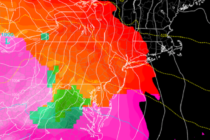
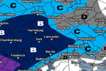
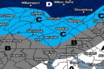
Discussion: Our weekend winter storm system has trended warmer since yesterday. The main reason? The upper-level low associated with the trough that will be swinging in is now modeled stronger. This propagates down to the surface by intensifying the primary

Read Full Article
Jan 13: Winter Storm Detected

Jan 13: Winter Storm Detected

🕔16:22, 13.Jan 2020

Discussion: On Friday morning low pressure will form somewhere in the Wyoming area and track eastward towards the E US. This low will encounter a strong (1040mb+) blocking surface high over SE Canada/extreme N Maine.  This high will do two

Read Full Article
Mild Start Cold Finish (Jan 13-17)

Mild Start Cold Finish (Jan 13-17)

🕔14:02, 12.Jan 2020

Discussion: We are through with the freakishly warm January conditions after today. Anomalously high ridging will continue over the E US this week but fade. That means that Mondy through Thursday daytime hours will still be above-average in temperature but

Read Full Article
Warm for Winter (Jan 10-12)

Warm for Winter (Jan 10-12)

🕔09:44, 10.Jan 2020

Discussion: The upper jet will be WAY to the N of NJ this weekend…like up in SE Canada. This will shape a highly anomalous ridge over the E US through Sunday. A large area of high pressure will set up

Read Full Article
Jan 7: Snowfall Approaching

Jan 7: Snowfall Approaching

🕔11:02, 7.Jan 2020

Discussion: Our system has trended towards an expanded field of snowfall. It hasn’t trended towards more snow than yesterday’s expectation just further N into New Jersey. There is going to be a sharp cutoff of precipitation on the N/NW side

Read Full Article
Jan 6: Set the Alarms

Jan 6: Set the Alarms

🕔16:46, 6.Jan 2020

Discussion: A very weak disturbance will form overnight tonight in the Tennessee Valley and track through the Delmarva Peninsula area by early Wednesday morning. This should deliver a period of rain-to-snow across parts of CNJ/SNJ between about 5pm and 10pm

Read Full Article
Snow in the Forecast (Jan 6-10)

Snow in the Forecast (Jan 6-10)

🕔16:44, 5.Jan 2020

Discussion: Tonight we should dip into the upper-20s/lower-30s (NNJ/SNJ) with NNJ/CNJ favored for a few flurries and snow showers. Then we’re pretty seasonal from Monday through Wednesday temperature wise…above freezing during the day and below freezing overnight. Tuesday PM is

Read Full Article
Unsettled Conditions Possibly End as Snow (Jan 3-5)

Unsettled Conditions Possibly End as Snow (Jan 3-5)

🕔16:52, 2.Jan 2020

Discussion: Conditions over the north pole, specifically the Polar Vortex (PV), remain unfavorable for a sustained cold and snowy pattern through at least January 15th. Upstream eastern Pacific conditions, specifically the EPO and PNA, remain unfavorable for any large slow

Read Full Article