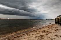
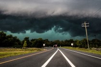
Back to homepage

Posts From Jonathan Carr

Milder Week Expected (Jan 25-29)

Milder Week Expected (Jan 25-29)

🕔20:11, 24.Jan 2016

We’re dropping well below freezing tonight but the week looks to moderate in temperature. The weekend holds great uncertainty as model guidance is trying to suggest another synoptic event. Let’s break it down. Monday (Jan 25) high temperatures should reach

Read Full Article
Historic Weekend Snowstorm Buries NJ

Historic Weekend Snowstorm Buries NJ

🕔08:32, 24.Jan 2016

Here’s a recap of the January 2016 historic weekend winter storm that impacted tens of millions of people in the Mid-Atlantic US. Friday Evening, The snowfall had started earlier than expected. This was reminiscent of how the great January 1996

Read Full Article
Jan 22: Final Snow Map for the Weekend Winter Storm

Jan 22: Final Snow Map for the Weekend Winter Storm

🕔18:12, 22.Jan 2016

The light gray area represents a sharp cut-off of snowfall. This is due to confluence and very dry air. The difference of 20 miles N or S could mean the difference between a dusting and up to 10 inches of

Read Full Article
Jan 21: Weekend Winter Storm Update

Jan 21: Weekend Winter Storm Update

🕔16:48, 21.Jan 2016

The latest model guidance as well as live observations of the system’s maturity to our SW are leading towards a colder solution for southern areas and less accumulations for points north. I have adjusted my map accordingly. The red line

Read Full Article
Jan 20: Weekend Winter Storm Update

Jan 20: Weekend Winter Storm Update

🕔20:31, 20.Jan 2016

We’re about 54 hours away from our weekend winter storm. Here’s my snow map: The light pink area is subject to lesser snowfall amounts due to possible mixing. Expect 40-60mph wind gusts off the ocean along with moderate to high

Read Full Article
Jan 19: Major East Coast Winter Storm Update

Jan 19: Major East Coast Winter Storm Update

🕔20:33, 19.Jan 2016

We’re just 72 hours from a possible major east coast winter storm and here’s what the latest data tells us. Today’s 12Z and 18Z model suites have trended colder for New Jersey. This means less potential mixing to the SE

Read Full Article
Cold Possibly Wintry Week Expected (Jan 18-22)

Cold Possibly Wintry Week Expected (Jan 18-22)

🕔20:23, 17.Jan 2016

Temperatures should crash overnight as an Arctic front passes through the region. This will set the stage for a cold week ahead of a possible late-week winter storm. Let’s break it down. Monday (Jan 18) high temperatures should be held in the

Read Full Article
Jan 17: Possible Snow Storm Detected!

Jan 17: Possible Snow Storm Detected!

🕔09:52, 17.Jan 2016

We have a lot to talk about. First, we have today’s possible light snow event. This was actually a system that I’ve been watching for a long time. It was aggressively modeled in a supportive pattern in the long-range forecasting

Read Full Article
Jan 15: Coastal Storm Approaching!

Jan 15: Coastal Storm Approaching!

🕔10:37, 15.Jan 2016

A powerful coastal storm will track from OBX to the benchmark tonight through tomorrow morning. The latest short-range model guidance (4k NAM + RGEM) suggest a low pressure intensity of ~990mb when it ejects over OBX and a sub-980mb intensity when

Read Full Article
Mixed Weather Expected (Jan 15-17)

Mixed Weather Expected (Jan 15-17)

🕔20:27, 14.Jan 2016

The weekend starts mild and rainy but ends cold with some light snow possible heading into Monday. Let’s break it down. Friday (Jan 15) high temperatures should range from 45-50 (NNJ elevations to the SNJ coast). The day might start

Read Full Article