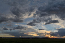
Milder Conditions (March 8-12)
Discussion: Monday looks like a day of transition as the colder air mass departs to our NE. N/NW flow will slowly give way to W/NW and ultimately W/SW flow by early Tuesday. This will allow warmer air from the SE


Discussion: Monday looks like a day of transition as the colder air mass departs to our NE. N/NW flow will slowly give way to W/NW and ultimately W/SW flow by early Tuesday. This will allow warmer air from the SE

Discussion: The backside of a trough over the NE US will feed our area with colder NW flow at the upper levels from now (Thursday) through most of the weekend until a narrow positive-axis trough swings through between Sunday and
Discussion: We should stay cold and rainy tonight into tomorrow morning as our weak but prolonged disturbance moves through. Tomorrow (Monday) winds should pick up out of the W/NW after late-AM clearing and persist into some of Tuesday. Peak wind

Discussion: An area of high pressure is moving through from W to E. It brought us a cold Thursday night but will now moderate temperatures with it’s departing return flow. The ocean is running 38-39F but the sun should take
Discussion: Tonight should be another cold one. Nothing crazy record breaking but lows dropping below freezing statewide (into 20s for much of NJ). The high pressure, that drove down the decaying Arctic air mass over NJ this weekend, will pass

Discussion: It just occurred to me that I haven’t released a fixed weekly product (Mon-Fri Outlook or Weekend Outlook) since late-January. February’s weather, so far, warranted daily wintry storm articles for the incredibly active winter pattern we’ve been in since
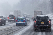
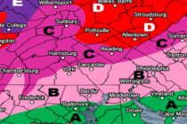
Discussion: The approaching winter storm is anything but a “start and end as snow” event. It’s an ugly mess of precipitation types including snow, sleet, freezing rain, and plain rain falling on a volatile surface line of freezing. The low
Discussion: The trend on most data over the last 24 hours has been for a colder solution Thursday-Friday. More like the solution I was thinking yesterday (what the GFS/Euro was advertising). The reason for the data changing is that the
Discussion: Precipitation so far today has been very isolated and drizzly with most areas still dry as of now. Ultra-short-range model guidance and live obs indicate similar conditions holding until about 11PM tonight. From 11PM into Tuesday morning, precipitation should
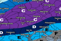
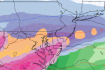
Discussion: Another ice storm is approaching and this one looks more potent. Where the recent one hit mostly 95 and SE, this one is targeting 95 and NW. There’s not much to say. The atmosphere is warm over New Jersey

LOCAL FORECAST | INTERACTIVE RADAR | LATEST NJ WEATHER ALERTS | WEDDING FORECAST| PRIVACY POLICY
© Copyright 2026 Weather NJ LLC. All Rights Reserved.
Some information that can be found on our website is provided by a private weather station and is not an officially recognized station for weather reporting. Though we always strive to achieve accurate reporting for our own use, it is important that you do NOT depend on the data provided here for any purpose.


