Great Fall Weekend Expected! (Oct 23-25)
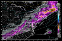
The weekend looks pretty good, aside from a few possible showers on Sunday morning. High pressure will be drifting through the northern area of our region which should keep it cool and dry Friday and Saturday. After the thin line