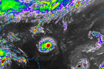
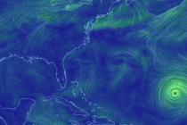
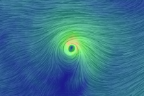
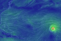
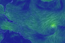
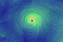
Back to homepage

Latest NJ Weather Alerts

Jan 29: Snow Approaching

Jan 29: Snow Approaching

🕔10:20, 29.Jan 2017

Snow is on the way for parts of SNJ. Here are my latest thoughts on amounts and timing… Disco: I’ve always been impressed with the upper-level setup surrounding this “first-of-four” snow possibilities this week. If you look at 500-700mb heights, there’s

Read Full Article
Jan 27: Snow Discussion

Jan 27: Snow Discussion

🕔10:39, 27.Jan 2017

Some snow possibilities are starting to show up on model guidance. Let’s break it down… If I had a nickel every time someone asked me “When’s it going to snow? or “Where’s the snow?” I’d be working Weather NJ full-time.

Read Full Article
Cold Dry Weekend Expected (Jan 27-29)

Cold Dry Weekend Expected (Jan 27-29)

🕔21:55, 26.Jan 2017

Rain has cleared out and we’re now looking cold and dry for the weekend. Let’s break it down… Disco: The frontal wave/disturbance that brought light rainfall to the region has cleared out. A cold front is moving through tonight-tomorrow and it

Read Full Article
Jan 24: The Return of Cold

Jan 24: The Return of Cold

🕔11:15, 24.Jan 2017

The January thaw is about to end as we approach a prolonged period of cold. Let’s break it down… First, a quick recap of the coastal storm. NWNJ saw wintry precipitation in the form of mostly sleet/some wet snow. The

Read Full Article
Jan 23: PM Coastal Storm Update

Jan 23: PM Coastal Storm Update

🕔19:06, 23.Jan 2017

Here’s how the rest of tonight should play out from here… The current radar is detecting sleet (pink) in NNJ and parts of CNJ due to a cold 925mb layer beneath a marginal 850-700mb. This is what’s preventing an all

Read Full Article
Jan 23: Coastal Storm Update

Jan 23: Coastal Storm Update

🕔10:43, 23.Jan 2017

The coastal storm is well underway but peak intensity is still to come. Let’s break it down… Right now, the primary surface low is about 988mb and tracking from W NC to OBX. Upper-level lows are closed off from 300-700mb

Read Full Article
Jan 22: Coastal Storm Approaching!

Jan 22: Coastal Storm Approaching!

🕔17:11, 22.Jan 2017

This will be the last predictive article heading into this event. All posts from this point forward will focus on live observations. We have 4 components of this system that we’re watching closely: Wintry precipitation, rain, wind and coastal flooding. Eastern

Read Full Article
Jan 21: Coastal Storm Update

Jan 21: Coastal Storm Update

🕔15:32, 21.Jan 2017

The prime impact window for this event is narrowing down to late Sunday night-early Tuesday AM. Let’s break it down… Disco: The upper-levels continue to strongly support a strong 250mb jet pattern enhancing and interacting with a cut-off 500mb low which

Read Full Article
Jan 20: Strong Coastal Storm Detected!

Jan 20: Strong Coastal Storm Detected!

🕔14:23, 20.Jan 2017

Models continue to suggest a strong coastal storm this Sunday night through Tuesday. While it’s possible for points NW to mix with wintry precipitation, wind and coastal disruption are looking like the main story. Let’s break it down… Disco: At the upper

Read Full Article
Jan 18: Initial Thoughts on Jan 23-24

Jan 18: Initial Thoughts on Jan 23-24

🕔19:43, 18.Jan 2017

A mature low pressure system is expected to impact our region in the January 23-24 period. Right now it looks like rain and wind for New Jersey. Disco: A negatively-tilted trough at the jet stream level is quite evident in

Read Full Article