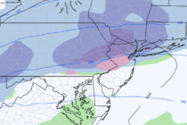
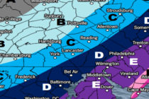
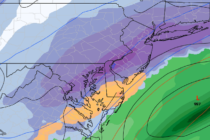
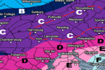
Cloudy Stormy Wet Conditions (May 3-5)
Discussion: The upper-jet looks pretty flat for the next week or so. I wouldn’t call it 100% zonal but low-amplitude for sure. When the jet rises a bit N of NJ we see milder temps and then when it’s slightly
Discussion: I know this outlook is a bit late so we’ll focus on tonight-forward. An upper-level ridge should dominate the region this week with above-average geopotential heights. This should keep the upper-level jet to the N of New Jersey through
Discussion: Some rain showers are moving across NJ right now (Thursday) and will continue this evening along a warm front. At some point early Friday the warm front will advance to our N and we’ll likely see a period of
Discussion: We have upper-level energy consolidating as it fizzles out over the OBX/Delmarva area region Monday. That should be just enough energy to power a small and weak coastal disturbance offshore. It’s really not a big deal but it could
Discussion: We continue to evolve towards a two-prong hit of rain and thunderstorms. The first will be pre-frontal activity in the warm sector this evening and the second will be the main expected storm period early Saturday morning. The front
Discussion: We’re now in the warm sector supported by high pressure near Bermuda and a series of low pressure disturbances tracking just NW of the Appalachian Mountains into Canada. This is why non-coastal areas spiked so warm today and why
Discussion: I’m watching Friday night through Saturday morning for another period of potential severe weather (like this past early-Monday morning). The first player involved is a low pressure system currently cutting way to our NW over the N Great Lakes.
Discussion: We’re cooler today (Monday) in the wake of a cold front passage. By mid-week an area of high pressure should set up over the SE US and bring back the warmth via SW return flow. Another frontal passage attached
Discussion: A well-organized low pressure system will track through Ohio, NW NY State and ultimately into Maine overnight into tomorrow. We’re in the correlating warm sector today (I don’t need to tell you that) but the cold front should push
Discussion: The main players on the field this weekend are an easterly-departing high and low cutting through the Great Lakes. This configuration should produce mild S flow for most of the weekend. Friday and Saturday daylight hours look pretty good.