Storm Update and Future Snow Chat

Storm Update and Future Snow Chat

🕔15:54, 30.Nov 2022

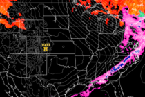
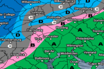
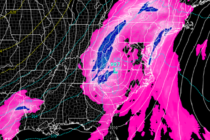
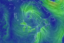
Discussion: The primary low in Canada is down to 978mb. Isobars are tightening and the attached cold front drapes all the way down into the SE US. High pressure is materializing over Oklahoma and will soon drift eastward, reinforcing the

Read Full Article
Wind Event Approaching

Wind Event Approaching

🕔15:07, 29.Nov 2022

Discussion: Tomorrow (Wednesday) is going to be one of those volatile days I spoke about in this week’s outlook. The setup includes strong upper-level dynamics (a vort-phasing trough) over the Great Lakes enhancing (bombing out) a surface low just N

Read Full Article
Volatile Conditions

Volatile Conditions

🕔12:03, 28.Nov 2022

Discussion: I’m seeing a much more wintry-like pattern beginning around Dec 5 for New Jersey. That doesn’t mean we’re getting a snowstorm on Dec 5. It simply means the atmosphere will become favorable for snow development at that point and

Read Full Article
Great for Travel. Watching the Weekend.

Great for Travel. Watching the Weekend.

🕔10:15, 21.Nov 2022

Discussion: This week looks straightforward. High pressure will be passing through/overhead from Monday-Thursday. This will produce clear skies, milder-feeling afternoons, and cold nights. Mon-Tues colder than Wed-Thurs. The setup looks ideal for anyone traveling Mon-Thurs and will be a nice

Read Full Article
Cold and Dry. Watching Next Weekend.

Cold and Dry. Watching Next Weekend.

🕔16:17, 17.Nov 2022

Discussion: We currently have a colder flow out of the W/NW. Overnight lows tonight (Thursday night) should fall into the 20s for most with coastal regions hanging in the 30s. A few isolated snow flurries and streamer showers have been

Read Full Article
First Snow Possible Tonight for NWNJ

First Snow Possible Tonight for NWNJ

🕔14:41, 15.Nov 2022

Discussion: Precipitation is approaching New Jersey from the SW and is already falling in some areas. No one should get too excited just yet. The snow that could happen tonight is mainly for the higher NWNJ elevations and will probably

Read Full Article
Colder Patten Sets In

Colder Patten Sets In

🕔12:59, 14.Nov 2022

Discussion: It looks like the roller coaster temperature swings will calm down now that we’re settled into a colder air mass and colder pattern overall. Temperatures should fall steadily through sunset into tonight (Monday night) sending most below freezing. We’ll

Read Full Article
Weekend Rainstorm Update

Weekend Rainstorm Update

🕔15:42, 9.Nov 2022

Discussion: Our cool streak (since Monday night’s cold front) is about to end as we roller coaster forward with temperatures again. High pressure is drifting out to sea and Nicole will make landfall in E FL before tracking N through

Read Full Article
Nicole’s Remnants Eyeing New Jersey

Nicole’s Remnants Eyeing New Jersey

🕔13:42, 8.Nov 2022

Discussion: Did anyone get to see the lunar eclipse this morning? Certainly, a more traditional fall feel this morning compared to the last few days. We’ll stay dry and clear for a few days (through Friday) as we gradually warm

Read Full Article
An Interesting Week Ahead

An Interesting Week Ahead

🕔14:40, 7.Nov 2022

Discussion: We’ve got an interesting week ahead. A total lunar eclipse, two fronts, roller coaster temperatures, remnants of Nicole, etc. all leading to a much colder pattern with even some snow showing up on long-range model guidance. A bit longer

Read Full Article