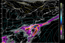
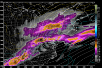
Back to homepage

Posts From Jonathan Carr

Cold, Wet & Windy Weekend Expected (Oct 31-Nov 2)

Cold, Wet & Windy Weekend Expected (Oct 31-Nov 2)

🕔20:38, 30.Oct 2014

Tomorrow looks decent for trick or treating but all eyes are on the coastal storm that will form from two different low pressure disturbances. New Jersey impacts include cold rain and gusty winds on Saturday followed by a temperature drop Saturday

Read Full Article
Oct 29: Weekend Storm Update

Oct 29: Weekend Storm Update

🕔17:45, 29.Oct 2014

Model guidance continues to suggest a strong low pressure disturbance forming off the coast of Delmarva/New Jersey this Saturday. Exact impacts for New Jersey will vary from coast to inland but strong northerly winds will be common throughout the entire

Read Full Article
Oct 28: First Snowflakes Possible this Weekend!

Oct 28: First Snowflakes Possible this Weekend!

🕔09:48, 28.Oct 2014

To be clear…snow accumulations are not expected. However, the chance for snow mixing in with cold rain is very possible, especially for the higher elevations of NWNJ. A low pressure disturbance will be sinking down from Canada and lifting out

Read Full Article
Oct 27: Erratic Temperatures Detected!

Oct 27: Erratic Temperatures Detected!

🕔11:36, 27.Oct 2014

I don’t know about you but I’m enjoying every minute of the warmer Fall we’ve been having. As we further transition towards Winter, we’ll see more and more temperature fluctuations. Each cold spell will last a little bit longer as

Read Full Article
Beautiful Week Expected (Oct 27-31)

Beautiful Week Expected (Oct 27-31)

🕔18:42, 26.Oct 2014

High pressure will continue to dominate for the first part of the week. That will keep temperatures above average until a frontal boundary swings through midweek and returns temperatures to seasonably average levels. A strong low pressure disturbance looks to move through

Read Full Article
Oct 22: Coastal Storm Update!

Oct 22: Coastal Storm Update!

🕔15:00, 22.Oct 2014

The coastal storm is now well formed about 175 miles east of the lower Delmarva Peninsula. Rain and wind will continue to wrap around it’s cyclonic flow well into tomorrow morning. Winds have been gusting to 25/30mph along the immediate

Read Full Article
Oct 21: Tuesday NJ Forecast Video

Oct 21: Tuesday NJ Forecast Video

🕔09:28, 21.Oct 2014

Watch this Weather Forecast Video covering the weather associated with our region, so you can start your day off right, by knowing what weather awaits you when you walk out your front door! Jonathan CarrJonathan Carr (JC) is the founder

Read Full Article
Dreary Week Expected (Oct 20-24)

Dreary Week Expected (Oct 20-24)

🕔09:49, 20.Oct 2014

Clouds cover will begin increasing today as a low pressure disturbance moves in from the NW and eventually forms a weak coastal storm. While some rainfall could actually start this evening, most of it will fall between Tuesday and Thursday.

Read Full Article
NJ Long Range Outlook – Closing Out October

NJ Long Range Outlook – Closing Out October

🕔17:22, 19.Oct 2014

It’s time to harness the true power of WeatherTrend360’s proprietary algorithms again as we close out October and head into November. First lets break New Jersey into proper climatological regions. We have the upper elevations of NWNJ, the interior coastal

Read Full Article
Oct 17: Coastal Storm Detected!

Oct 17: Coastal Storm Detected!

🕔19:00, 17.Oct 2014

An upper level low pressure disturbance will move from Canada across the Great Lakes and stall out near the benchmark (70N/40W) next week. Impacts should be felt as early as Tuesday evening. There is uncertainty as to when it will

Read Full Article