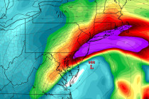
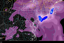
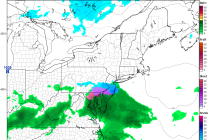
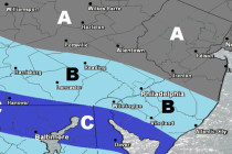
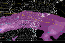
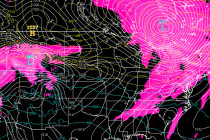
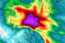
Back to homepage

Feature POST on Homepage

Aug 27: Erika Likely to Threaten SE US Coast

Aug 27: Erika Likely to Threaten SE US Coast

🕔21:27, 27.Aug 2015

Tropical Storm Erika remains weak in the NE Caribbean Sea. She will battle a strong upper-level wind shear environment over the next 24-36 hours as well as possibly the higher elevations of Hispaniola. This should keep her weak despite healthy

Read Full Article
Aug 26: East Coast Impact from Erika Gaining Confidence

Aug 26: East Coast Impact from Erika Gaining Confidence

🕔11:28, 26.Aug 2015

Erika has slightly intensified overnight and this morning. The big question is “How will this impact the US east coast?” Well, the Bahamas and Florida, as stated yesterday, should begin taking Erika seriously. We’re still a ways out and model guidance

Read Full Article
Aug 25: Monitoring Erika

Aug 25: Monitoring Erika

🕔10:37, 25.Aug 2015

Invest 98L has evolved into Tropical Storm Erica who presents a much more realistic threat to the east coast than Danny ever did. She has less (but some) shear to deal with but once into the Bahamas, she could intensify into

Read Full Article
Aug 24: Tropics Update

Aug 24: Tropics Update

🕔12:32, 24.Aug 2015

Danny has sheared apart into tropical remnants which verified the most-likely scenario. Remnants however will continue to impact the NE Caribbean with rainfall and only light-to-moderate tropical winds. The only thing worth watching is if such tropical remnants re-intensify “if”

Read Full Article
Mixed Weather Expected (Aug 24-28)

Mixed Weather Expected (Aug 24-28)

🕔15:47, 23.Aug 2015

General Discussion: A low pressure system of tropical interest (Invest 97L) is spinning off the east coast but presents no direct threat of landfall. Therefore, coastal regions should take notice of increased surf and rip currents through at least Wednesday

Read Full Article
Aug 23: Still Watching the Tropics

Aug 23: Still Watching the Tropics

🕔09:49, 23.Aug 2015

Danny has been weakening over the last 24-36 hours due to an unfavorable upper level environment of wind shear and dry air. He will continue to weaken in tropical cyclone intensity but should still bring widespread heavy rainfall to the

Read Full Article
Aug 21: Hurricane Danny Update

Aug 21: Hurricane Danny Update

🕔11:57, 21.Aug 2015

Hurricane Danny has intensified. He has been able to stay just south of inhibitive factors such as dry Saharan air/dust, and wind shear. He could possibly intensify further but eventually, he’s going to have to cross a strong wind shear

Read Full Article
Weekend Looks Okay (Aug 21-23)

Weekend Looks Okay (Aug 21-23)

🕔18:59, 20.Aug 2015

So after the heavy rainfall tonight and tomorrow, the weekend should be okay for most. We have a lot of dynamics in play with a passing cold front, a weak area of low pressure in the Atlantic and a cold

Read Full Article
Aug 20: Hurricane Danny has Formed!

Aug 20: Hurricane Danny has Formed!

🕔10:29, 20.Aug 2015

Hurricane Danny, per latest data, has intensified down to a 992mb low pressure center. Sustained max winds are now up to 75mph. He is currently moving towards the NE region of the Caribbean as most model guidance suggested over the last 48-72

Read Full Article
Aug 19: Tropical Storm Danny Update

Aug 19: Tropical Storm Danny Update

🕔10:28, 19.Aug 2015

Tropical Storm Danny is currently located at 11.3N 40.2W and heading in the general direction of the NE Caribbean region (~Northern Lesser Antilles). He should intensify into a hurricane by no later than tomorrow evening but possibly as early as overnight

Read Full Article