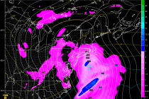
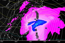
Back to homepage

Feature POST on Homepage

Aug 6: Rain Storm Update

Aug 6: Rain Storm Update

🕔10:03, 6.Aug 2015

Widespread synoptic rainfall is already organizing around a low pressure disturbance moving into W. Kentucky. It should reach New Jersey as early as later this evening but should clear out before Saturday. This leaves just a single potential washout day

Read Full Article
Aug 5: Watching the Weekend Rain Storm

Aug 5: Watching the Weekend Rain Storm

🕔12:29, 5.Aug 2015

I’ve been watching this possibility on model guidance for a few days now. It has actually been behaving like a winter storm in the sense of GFS vs Euro (SE progressive bias vs amplification bias). In this case, it looks

Read Full Article
Aug 4: Afternoon Thunderstorms Possible for SNJ

Aug 4: Afternoon Thunderstorms Possible for SNJ

🕔10:08, 4.Aug 2015

The thunderstorm threat today will primarily be for SNJ during afternoon-early evening hours. A frontal boundary will be moving through the region today and somewhat stall over the Baltimore<->Atlantic City axis from W to E. As energy moves along this

Read Full Article
Aug 3: Thunderstorms Possible for NNJ Later

Aug 3: Thunderstorms Possible for NNJ Later

🕔11:57, 3.Aug 2015

Today should be mostly sunny in New Jersey however some funky energy should move through to our NW later this evening and overnight. The main player is a low pressure disturbance in SE Canada which will drag a series of frontal

Read Full Article
Mixed-Weather Expected this Week (Aug 3-7)

Mixed-Weather Expected this Week (Aug 3-7)

🕔16:32, 2.Aug 2015

Warm fronts, cold fronts, humidity, storms, rain and sunshine—we’ve got it all this week. Let’s break down how it should play out… Monday high temperatures should reach about 90 statewide, give or take a few. Humidity should be noticeably elevated.

Read Full Article
August 2015 Outlook

August 2015 Outlook

🕔13:17, 31.Jul 2015

It’s time to use the crystal ball and harness the WeatherTrends360 proprietary weather algorithms for a look at August 2015. But first lets break New Jersey into proper climatological regions. We have the upper elevations of NNJ/NWNJ, the interior coastal plain (SWNJ through CNJ

Read Full Article
Warm & Dry Weekend Expected (July 31-Aug 2)

Warm & Dry Weekend Expected (July 31-Aug 2)

🕔19:56, 30.Jul 2015

With the cold front through, dry and sunny conditions are expected for the weekend. Let’s break each day down: Friday high temperatures should reach the mid-to-upper 80s with a much drier feel. Skies should be mostly sunny. Winds should be

Read Full Article
July 30: Thunderstorms Expected!

July 30: Thunderstorms Expected!

🕔09:51, 30.Jul 2015

A cold front will push a line of showers and thunderstorms through New Jersey today from NW to SE. As far as timing goes, NWNJ will get hit first in the afternoon and SENJ will get hit last later this

Read Full Article
July 29: It’s Gonna Be a Hot One Today!

July 29: It’s Gonna Be a Hot One Today!

🕔10:07, 29.Jul 2015

The National Weather Service has issued Excessive Heat Warnings and Air Quality Alerts with good reason. Today’s temperatures should easily soar into the 90s for many with heat indices approaching 100. When the low-to-mid levels of the atmosphere are this

Read Full Article
Typical Summer Week Expected (July 27-31)

Typical Summer Week Expected (July 27-31)

🕔10:57, 27.Jul 2015

We’re looking at a mixed bag of normal mid-summer weather in New Jersey this week. Let’s break each day down: Monday high temperatures should reach the mid-80s. There will be lengthy periods of sun with noticeable humidity but isolated-to-scattered showers

Read Full Article