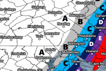
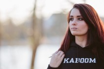
Back to homepage

Latest NJ Weather Alerts

June 21: Watching Afternoon Thunderstorms

June 21: Watching Afternoon Thunderstorms

🕔10:20, 21.Jun 2016

The frontal boundary approaching from our NW has slowed down a bit. This morning’s round of showers and thunderstorms, that rode the front, have shoved off to our SE and are no longer associated. Because of this little delay in frontal advancement,

Read Full Article
Mixed Weather Expected (June 20-24)

Mixed Weather Expected (June 20-24)

🕔21:09, 19.Jun 2016

The high pressure that brought us a beautiful weekend will sink into the SE US and allow a cold front to pass through on Tuesday. A low pressure disturbance could then bring some rain from the Great Lakes direction through

Read Full Article
Gorgeous Weekend Expected! (June 17-19)

Gorgeous Weekend Expected! (June 17-19)

🕔12:36, 16.Jun 2016

Lingering low pressure over the S. Mid-Atlantic US could bring some more rain to SNJ early Friday morning. After that and through the weekend however looks absolutely gorgeous as high pressure takes control of the region. Let’s break it down:

Read Full Article
Mostly Nice Week Expected (June 13-17)

Mostly Nice Week Expected (June 13-17)

🕔19:33, 12.Jun 2016

High pressure should have control of most of the week. We’ll have to watch a low pressure disturbance towards the end of the week to see how much impact it will have heading into the weekend. Let’s break it down:

Read Full Article
Mostly Nice Weekend Expected (June 10-12)

Mostly Nice Weekend Expected (June 10-12)

🕔10:45, 10.Jun 2016

Friday and Sunday are looking pretty nice. Saturday is complicated but not an all day washout. Let’s break it down: Friday (June 10) high temperatures should range in the 70s statewide. Skies should be mostly sunny with a pleasant feel.

Read Full Article
June 9: More Thunderstorms Detected

June 9: More Thunderstorms Detected

🕔10:55, 9.Jun 2016

Rain and thunderstorms are possible this Saturday afternoon-evening. Right now we have high pressure setting up over the general Ohio Valley region which will keep us cool and dry through Friday. Some might call it comfortable. Some might call it

Read Full Article
Week Starts Warm. Ends Cooler (June 6-10)

Week Starts Warm. Ends Cooler (June 6-10)

🕔09:51, 6.Jun 2016

I took the above photo last night in Surf City, NJ after the line of thunderstorms rolled through. The most common reports from most were just brief periods of moderate-to-heavy rainfall with a few boomers. Some however saw damaging winds.

Read Full Article
June 5: Thunderstorms Approaching!

June 5: Thunderstorms Approaching!

🕔10:37, 5.Jun 2016

Thunderstorm energy is starting to build to our W/NW as it begins its NJ approach. The warm front is pushing through from S to N. Dew point temperatures are already in the lower-70s in extreme SNJ and this will push N

Read Full Article
June 3: Thunderstorms Expected Sunday

June 3: Thunderstorms Expected Sunday

🕔21:38, 3.Jun 2016

Thunderstorms are expected on Sunday, some possibly severe. It’s a complex setup with a warm front pushing through (from S to N) in the morning, a period of clearing in the afternoon followed by a cold front pushing through (from

Read Full Article
Unsettled Weekend Expected (June 3-5)

Unsettled Weekend Expected (June 3-5)

🕔12:12, 2.Jun 2016

Between the remnants of Bonnie and several frontal passages, this weekend looks unsettled. Today we’re seeing onshore flow with temperatures expected to reach into the 70s along the coast and 80s away from the ocean. With scattered clouds it should

Read Full Article