Weekend Outlook (Feb 15-17)
Discussion: The three signals have all trended less snowy. All three of them. If you like snow then you should just stop reading and check back in a few days to see if the third signal trended snowier. The first signal


Discussion: The three signals have all trended less snowy. All three of them. If you like snow then you should just stop reading and check back in a few days to see if the third signal trended snowier. The first signal

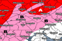
Discussion: There are three snow signals between this Saturday and mid next week. The first is this Saturday afternoon through early Sunday morning. Currently the guidance points towards something similar to what happened this past Sunday night/Monday morning in SNJ. There’s
Discussion: Our second system is disrupting NJ travel quite a bit today for NNJ and parts of CNJ. Most of SNJ has changed over to rain and will not go back until this event concludes late tonight/early tomorrow. The notable trends
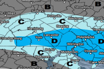
Click here to view full resolution map! Click here to view full resolution map! Discussion: This article and its snow maps are being advertised as “from this point forward” meaning they do not include any snow or ice that has fallen
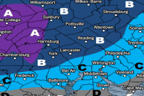
Click here to view full resolution map! Click here to view full resolution map! Discussion: Since this second system features both snow and ice we’ve separated the impact maps accordingly above. System one should finish up by mid-to-late morning tomorrow (Monday).
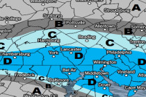
Click here to view full resolution map! Discussion: Our first system is approaching from the W. High pressure is sliding E out to sea from Delmarva and the back-side return flow will feed our precipitation shield with moisture and warmth. But
Two wintry systems are expected in the first half of this week. To be outright neither system is a big snow storm however they should have high-impact on travel. At the end of the day we’re here for safety… First

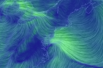
Discussion: The upper-level pattern is whack. There’s a split-flow near the NW US and a convergence zone in the central US. Friday should reach well into the 50s for most as NJ is warm-sectored. A cold front should then push

It’s time to harness WeatherTrends360 technology and look at the rest of February 2019. WeatherTrends360 algorithms are documented with an 84% verification rate and are based on oceanic water cycles, time table series and very complex mathematics. The best takeaway from this

Discussion: The brutal cold pattern is relaxing for this week. Over the next few mornings the main concern is fog with SNJ still having light snow pack under warm air advection. The phenomena known as freezing fog is possible overnight tonight

LOCAL FORECAST | INTERACTIVE RADAR | LATEST NJ WEATHER ALERTS | WEDDING FORECAST| PRIVACY POLICY
© Copyright 2026 Weather NJ LLC. All Rights Reserved.
Some information that can be found on our website is provided by a private weather station and is not an officially recognized station for weather reporting. Though we always strive to achieve accurate reporting for our own use, it is important that you do NOT depend on the data provided here for any purpose.


