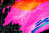
Colder Conditions (Oct 30-Nov 1)
Discussion: Two dips in the jet (troughs) should push through NJ in the near future. One Friday and another Monday-Tuesday. Said days will therefore feel noticeably colder. Between the dips should be some moderation for Saturday and Sunday but still