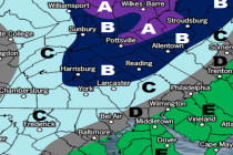
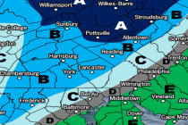
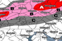
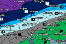
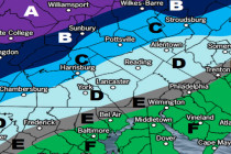
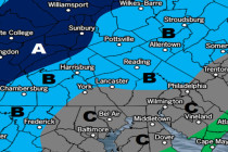
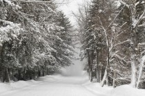
Back to homepage

Posts From Jonathan Carr

Wet Start Beautiful Finish (June 23-25)

Wet Start Beautiful Finish (June 23-25)

🕔21:33, 22.Jun 2017

Most of the weekend looks good aside from Cindy’s remnants. Let’s break it down… Discussion: The entire weekend forecast revolves around Cindy’s remnants which will be absorbed into an approaching upper-level longwave trough and pushed through the east coast between now and Saturday

Read Full Article
June 19: Thunderstorm Schedule

June 19: Thunderstorm Schedule

🕔11:55, 19.Jun 2017

The severe thunderstorm potential has not backed down. Here’s what to expect today… Please click here to view full resolution storm impact map. Discussion: More than adequate instability and sufficient wind shear parameters coupled with soupy dew points and a cold

Read Full Article
Stormy Start (June 19-23)

Stormy Start (June 19-23)

🕔23:24, 18.Jun 2017

Monday’s thunderstorm threat has the headline this week. Let’s break it down… Discussion: The severe thunderstorm threat remains firmly in place for Monday as a cold front is expected to plow through this haunting humid air mass. We have more

Read Full Article
June 17: Possible Thunderstorms Detected

June 17: Possible Thunderstorms Detected

🕔11:20, 17.Jun 2017

The Monday thunderstorm threat is increasing. Let’s break it down… Discussion: A cold front is expected to push through on Monday from W to E. Right now it looks like the frontal passage will occur Monday night into Tuesday morning with

Read Full Article
Warm Unsettled Weekend Expected (June 16-18)

Warm Unsettled Weekend Expected (June 16-18)

🕔10:55, 16.Jun 2017

By no means a washout but certainly a few unsettled periods. Let’s break it down… Discussion: A warm front has pushed through hence the southerly flow of warm/moist air. Convergence over the E US, from departing anti-cyclonic high pressure flow

Read Full Article
Hot Start Comfortable Finish (June 12-16)

Hot Start Comfortable Finish (June 12-16)

🕔11:08, 12.Jun 2017

After a hazy, hot and humid start, we moderate some. Let’s break it down… Discussion: The 250mb jet guidance indicates that the strongest stream winds will remain to our N this week. At 500mb, above-average height anomalies look to hang

Read Full Article
Awwww Yeah! (June 9-11)

Awwww Yeah! (June 9-11)

🕔21:43, 8.Jun 2017

Summery weather is on tap for the weekend. Let’s break it down… Discussion: That coastal storm just missed us to our SE. It’s currently wrapping up pretty tight (currently 999mb and dropping) and should graze the Cape Cod/Gulf of Maine area

Read Full Article
More Cool and Unsettled Weather (June 5-9)

More Cool and Unsettled Weather (June 5-9)

🕔22:33, 4.Jun 2017

This week should be cool and wet with warmer and drier hopes for the weekend. Let’s break it down… Discussion: 500mb heights look to stay below-average over the Mid-Atlantic US through the June 12/13 period. An upper-level low within the broad

Read Full Article
Mostly Dry Weather Expected (June 2-4)

Mostly Dry Weather Expected (June 2-4)

🕔21:47, 1.Jun 2017

Most of the weekend looks dry. Let’s break it down… Discussion: An area of high pressure is moving into the region for the weekend. The eastern side of its approaching anti-cyclonic flow should dry us out but keep us cooler

Read Full Article
Hop Sauce Festival Weather Looking Good!

Hop Sauce Festival Weather Looking Good!

🕔19:44, 1.Jun 2017

Weather NJ is honored to provide a special event forecast for the fourth annual Hop Sauce Festival this Saturday, June 3 from 11AM to 7PM. The event takes place on the ball field in Beach Haven, NJ (Long Beach Island)

Read Full Article