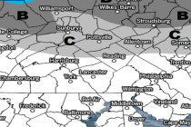
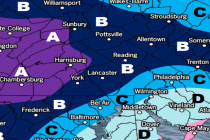
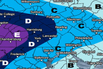
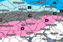
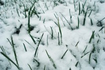
Back to homepage

Posts From Jonathan Carr

Aug 8: Watching the Tropics

Aug 8: Watching the Tropics

🕔09:45, 8.Aug 2017

Franklin has made landfall on the Yucatan Peninsula and will re-emerge over the SW Gulf of Mexico before making another landfall on the E coast of Mexico. No impacts to New Jersey or even the US are expected from such.

Read Full Article
Wet Start Expected (Aug 7-11)

Wet Start Expected (Aug 7-11)

🕔16:48, 6.Aug 2017

This week should start wet and stormy but conditions then improve… Discussion: At the upper-levels we have below-average to average heights to start this week, thanks to a series of upper-level troughs swinging through the region. Heights will then build mid-week

Read Full Article
Conditions to Improve (Aug 4-6)

Conditions to Improve (Aug 4-6)

🕔18:22, 3.Aug 2017

We’re looking at a wet start for some but Saturday through Sunday eventually looks beautiful. Let’s break it down… Discussion: An upper-level trough will move through the Great Lakes into SE Canada, dragging a cold front through New Jersey Saturday

Read Full Article
2017 Hobie North American Championship Forecast

2017 Hobie North American Championship Forecast

🕔23:01, 2.Aug 2017

Weather NJ is absolutely flattered that the International Hobie Class Association reached out for a special event forecast! Their 2017 Hobie Mini Mega North American Championships are being held in the Sandy Hook Bay on August 4-11. Each morning, a customized

Read Full Article
August 2017 Discussion

August 2017 Discussion

🕔12:18, 1.Aug 2017

It’s time to harness the WeatherTrends360 proprietary weather algorithms to see how August of 2017 should play out. But first lets break New Jersey into proper climatological regions. We have the higher elevations of NNJ/NWNJ, the interior coastal plain (SWNJ through CNJ and into NENJ

Read Full Article
Temps and Humidity Rebound (July 31-Aug 4)

Temps and Humidity Rebound (July 31-Aug 4)

🕔11:21, 31.Jul 2017

This week should start warm and pleasant but end hot and muggy. Let’s break it down… Discussion: The main players driving this week’s weather are first, an area of high pressure moving from the Great Lakes towards Bermuda and second,

Read Full Article
I’ve Seen Better Weekends (July 28-30)

I’ve Seen Better Weekends (July 28-30)

🕔20:47, 27.Jul 2017

Here’s what to expect this weekend… Discussion: Not much has changed since yesterday’s article analysis. We still have an upper level low moving through the Mid-Atlantic US over the next 72 hours. We also however have an upper level low moving

Read Full Article
Coastal Storm to Open Weekend

Coastal Storm to Open Weekend

🕔20:50, 26.Jul 2017

Lots of rain on the way. Let’s break it down… Discussion: The jet stream is about to take a dip over the E US. An upper-level shortwave is just getting started N of Montana which will descend and develop into

Read Full Article
Heat Wave Expected to Break (July 24-28)

Heat Wave Expected to Break (July 24-28)

🕔18:57, 23.Jul 2017

Finally, some relief from the heat and humidity… Discussion: An upper level shortwave will miss a connection with the northern stream. It will instead break off over our region as a temporary cut-off low aloft for the first half of

Read Full Article
Heat Wave Continues (July 21-23)

Heat Wave Continues (July 21-23)

🕔07:52, 21.Jul 2017

Another hot and unsettled weekend is expected. Let’s break it down… Discussion: The 250mb jet and 500mb dynamics are rather boring. A very zonal look for the weekend with the strongest streak to our N and average heights. What will

Read Full Article