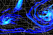
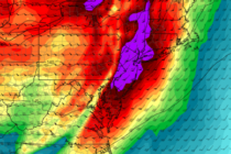
Back to homepage

Feature POST on Homepage

Feb 26: Light Snow Targeting NNJ

Feb 26: Light Snow Targeting NNJ

🕔17:11, 26.Feb 2019

Click here for full-resolution snow map! Discussion: From the upper-levels, there’s nothing to write home about. We have a very flat and zonal flow across the US and therefore tomorrow’s disturbance will be a quick mover. There should be two waves

Read Full Article
Colder Conditions Expected (Feb 25-Mar 1)

Colder Conditions Expected (Feb 25-Mar 1)

🕔19:29, 24.Feb 2019

Discussion: The powerful Great Lakes storm is currently pushing a cold front through NJ with the high winds tonight and tomorrow. This will lower 500mb geopotential heights for the time being but the upper-level flow looks very zonal (flat across

Read Full Article
Feb 24: Wind Storm Approaching

Feb 24: Wind Storm Approaching

🕔11:37, 24.Feb 2019

Discussion: Upper-level energy has aggressively tracked across the US from SW to NE. This upper-level energy is powering a strong surface low which has just tracked through the Great Lakes and will continue towards SE Canada. The low currently has a centralized

Read Full Article
Mixed Weather Conditions (Feb 22-24)

Mixed Weather Conditions (Feb 22-24)

🕔20:34, 21.Feb 2019

Saturday Update (12:30pm 2/23/2019): Light to moderate rain should begin this evening by (6pm for SNJ, 8pm for CNJ, 9pm for NNJ). A break is then expected between about midnight and 4am tomorrow morning. A heavier batch of rain should

Read Full Article
Feb 20: Update

Feb 20: Update

🕔15:28, 20.Feb 2019

Discussion: The front-end snow phase of this system is coming to an end. Precipitation has become very light but still existent. Not heavy enough to sustain mid-daylight hour accumulations. Therefore whatever you have snow-wise now is likely it. Snowfall performed slightly

Read Full Article
Feb 19: Winter Storm Approaching

Feb 19: Winter Storm Approaching

🕔16:54, 19.Feb 2019

  UPDATE: We’ve made a few small tweaks to the snow map as live-casting begins. We’ve removed the locally higher amounts language from all zones and opened up the lower-end boundary of the jackpot zone (B). Example: Zone B is

Read Full Article
Feb 18: Wednesday Travel Safety Concerns Grow

Feb 18: Wednesday Travel Safety Concerns Grow Updated

🕔16:47, 18.Feb 2019

Click here to view full resolution snow/sleet map! Click here to view full resolution freezing rain map! Discussion: This Wednesday’s winter storm will not be a major snow event. It could however present travel safety hazards for Wednesday PM travel. The

Read Full Article
Feb 16: Light Snow Targeting NNJ

Feb 16: Light Snow Targeting NNJ

🕔14:26, 16.Feb 2019

Click here to view full resolution map! Discussion: A weak area of low pressure will track across NJ from W to E between Sunday evening and Monday morning. No tricks or curve balls. It’s fairly straight forward. I’m not seeing much

Read Full Article
Weekend Outlook (Feb 15-17)

Weekend Outlook (Feb 15-17)

🕔20:41, 14.Feb 2019

Discussion: The three signals have all trended less snowy. All three of them. If you like snow then you should just stop reading and check back in a few days to see if the third signal trended snowier. The first signal

Read Full Article
Feb 13: Tracking More Snow

Feb 13: Tracking More Snow

🕔21:28, 13.Feb 2019

Discussion: There are three snow signals between this Saturday and mid next week. The first is this Saturday afternoon through early Sunday morning. Currently the guidance points towards something similar to what happened this past Sunday night/Monday morning in SNJ. There’s

Read Full Article