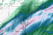
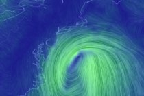
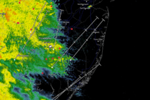
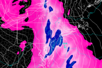
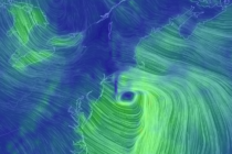
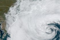
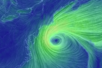
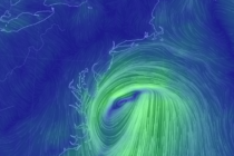
Back to homepage

Feature POST on Homepage

March 21: Morning Winter Storm Update

March 21: Morning Winter Storm Update

🕔11:10, 21.Mar 2018

Discussion: We have a snow/sleet/rain line/situation currently near the I-95 corridor. I expect this to advance to the SE between now and afternoon hours (possibly earlier) as the low-mid level temperatures crash. Precipitation should then bring this colder air down

Read Full Article
March 20: Final Call Snow Map

March 20: Final Call Snow Map

🕔16:55, 20.Mar 2018

  Please click here for full-resolution snow map! Discussion: I want to start off saying that this forecast has high bust potential in either direction. Model guidance and live observations have been ridiculously tricky to get a hold of even now,

Read Full Article
March 19: Winter Storm Update

March 19: Winter Storm Update

🕔16:55, 19.Mar 2018

Please click here for full-resolution wave 1 snow map! Please click here for full-resolution wave 2 snow map! Discussion: The overall Tuesday-Wednesday event is now broken down into two individual waves. The first wave is mostly due to the Pacific shortwave

Read Full Article
March 18: Snow Targeting New Jersey

March 18: Snow Targeting New Jersey

🕔16:57, 18.Mar 2018

Please click here for full-resolution snow map! Discussion: The Pacific shortwave involved should track across the US from W to E along ~38N between now and Tuesday morning. Some northern stream energy should then try and inject into the trough Tuesday

Read Full Article
March 17: Snow Storm Update

March 17: Snow Storm Update

🕔17:05, 17.Mar 2018

Discussion: The models are still all over the place with regard to surface output. The upper-levels are starting to make a little more sense however. It looks like we’ll see a brief +PNA spike fed by an Alaskan upper-level low

Read Full Article
March 15: East Coast Winter Storm Signal Growing

March 15: East Coast Winter Storm Signal Growing

🕔19:06, 15.Mar 2018

Discussion: Given the active pattern we’re in, I’m gaining confidence in an east coast winter storm next ~Tuesday-Wednesday. My argument is not because of the modeled surface snow maps flying around. About the only guidance worth reasonably considering from this range are

Read Full Article
March 13: Final Storm Update and a Look Ahead

March 13: Final Storm Update and a Look Ahead

🕔12:42, 13.Mar 2018

Discussion: In my opinion the Upper-Level Low (ULL) moved into the Great Lakes region a hair quicker than expected yesterday-overnight. Also, it crossed the US border with a heading a hair closer to due S rather than S/SE. This rippled through to

Read Full Article
March 12: Winter Storm Approaching

March 12: Winter Storm Approaching

🕔12:52, 12.Mar 2018

Please click here for full-resolution snow map! Discussion: The primary coastal surface low has formed off South Carolina. It should track just off OBX today and then just to the SE of the 40N/70W benchmark by Tuesday morning. At 500mb, the

Read Full Article
March 11: Winter Storm Expected

March 11: Winter Storm Expected

🕔17:30, 11.Mar 2018

Please click here for full-resolution snow map! Discussion: Today is a relatively mild nice sunny day and with good reason. The sun angle is rapidly increasing and the clock adjustment even further brings it home. I want this idea to set

Read Full Article
March 10: Winter Storm Concern Growing

March 10: Winter Storm Concern Growing

🕔18:12, 10.Mar 2018

Discussion: I wish I had more to give you at this point but we’re still in a holding pattern due to the complexity of the upper-level physics. We are looking slightly snowier than yesterday though. This is no longer about the

Read Full Article