Cool and Dry (Oct 4-6)
Discussion: A piece of upper-level energy has broken off of the NW US trough and made its way across S Canada to the trough currently swinging through the NE US. This energy is meeting up with the southern stream energy




Discussion: A piece of upper-level energy has broken off of the NW US trough and made its way across S Canada to the trough currently swinging through the NE US. This energy is meeting up with the southern stream energy

It’s time to harness WeatherTrends360 technology and look at how October 2019 should play out. WeatherTrends360 algorithms are documented with an 84% verification rate and are based on oceanic water cycles, time table series and very complex mathematics. The best

Discussion: The above image has been repetitively used recently and with good reason. Many are complaining that it’s too hot for this late in the year. We’ve had some transient cold snaps but nothing lasting. Well…the pattern is about to

Discussion: Another upper-level ridge will begin building over the E US this weekend which should last through at least Thursday morning. This should produce several days of well above-average temperatures at the surface. One of those days is this Saturday.

Discussion: Monday looks like the third and final day of the mini-warm streak that began yesterday (Saturday). A cold front should push through Monday night into Tuesday morning and return the region to refreshing conditions through Friday. Then another upper-level

Discussion: A quick safety note to everyone along the Jersey coast. There’s a lot of hurricane activity in the Atlantic Ocean. Humberto is pulling away and Jerry will likely make a close pass at Bermuda early next week. None of

Discussion: Upper-level ridging should dominate the pattern this week. As the ridge slowly builds and approaches (Monday-Thursday) NJ should find itself under northerly 500mb flow. The warmest areas of the US this week should be closer to the Great Lakes,
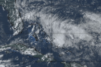
Discussion: There’s three things I’d like to talk about: Tonight: Rain and thunderstorms will continue to push southward through the rest of NJ this evening. I expect them to clear the tip of SNJ by ~10pm. There’s an area of
Discussion: Hopefully everyone enjoyed the recent taste of fall behind Dorian’s departure. We’re about to be reminded that it’s still summer however. A few different areas of high pressure in the W Atlantic Ocean will pump a ridge over the
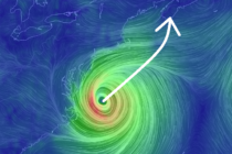
Discussion: Hurricane Dorian made landfall at Cape Hatteras, NC early this morning. There is some debate as to whether it was technically a landfall since the exact center of the eye might have missed land. But since Cape Hatteras went

LOCAL FORECAST | INTERACTIVE RADAR | LATEST NJ WEATHER ALERTS | WEDDING FORECAST| PRIVACY POLICY
© Copyright 2026 Weather NJ LLC. All Rights Reserved.
Some information that can be found on our website is provided by a private weather station and is not an officially recognized station for weather reporting. Though we always strive to achieve accurate reporting for our own use, it is important that you do NOT depend on the data provided here for any purpose.


