Back to homepage

Latest NJ Weather Alerts

Colder Air Briefly Returns

Colder Air Briefly Returns

🕔14:38, 3.Dec 2023

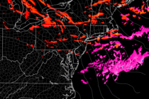
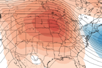
Discussion: A ridge is currently (as of Sunday afternoon) departing the E US. With it will go our above-average temperatures and the series of disturbances that brought rain this past Friday and today (Sunday). The rest of this week should

Read Full Article
Cloudy and Unsettled

Cloudy and Unsettled

🕔14:41, 1.Dec 2023

Discussion: It’s December 1, the start of meteorological winter. If you follow my baseball-to-winter analogy, the first batter has stepped up to the plate in the first inning. We have a long ballgame to go with the 9th inning ending

Read Full Article
What to Expect this Winter 2023-2024

What to Expect this Winter 2023-2024

🕔17:00, 30.Nov 2023

Forecast Discussion: This is not a winter forecast. I am not going to tell you your fortune in the form of snow inches or ice accumulation between now and late March. Just want to be crystal clear about that. I

Read Full Article
First Snowflakes of the Season for Many

First Snowflakes of the Season for Many

🕔11:08, 28.Nov 2023

Forecast Discussion: I had a feeling this was likely today, as mentioned in yesterday’s weekly outlook. The coldest air of the season yet is blowing across the southern Great Lakes, picking up moisture via evaporation, and carrying it E/SE to

Read Full Article
First Shot of Winter Cold Arrives

First Shot of Winter Cold Arrives

🕔15:39, 27.Nov 2023

Discussion: I’m seeing mostly an upper level (250mb) converging split flow pattern for the E US this week. At 500mb, most data suggests a trough to start this week that yields to a ridge for this weekend and then back

Read Full Article
Thanksgiving Travel Plan

Thanksgiving Travel Plan

🕔16:47, 20.Nov 2023

Discussion: Not much to deduce from the upper levels as most flow is zonal with alternating height profiles. If you are going to travel this week, it will be dry today through tomorrow afternoon. Tuesday afternoon through Tuesday night and

Read Full Article
Warm Snap Ends

Warm Snap Ends

🕔16:29, 16.Nov 2023

Discussion: We’re currently (Thursday) under the warmer influence of a ridge that will depart the E US by Saturday morning. Areas away from the ocean should dip into the 30s overnight tonight (Thursday night) with coastal areas holding closer to

Read Full Article
Cold Start Mild Finish

Cold Start Mild Finish

🕔17:00, 13.Nov 2023

Discussion: Models were correct about a week ago in that a ridge would develop now, out in the W/C US, and reciprocate a colder trough for the extreme EC which includes NJ. This should start us off colder this week

Read Full Article
Colder Air Settles In

Colder Air Settles In

🕔15:16, 9.Nov 2023

Discussion: Not seeing anything noteworthy in the upper levels for this week. A ridge will try to develop out W but not quite W US…more like W/C US. This will still reciprocate a trough for the E US (the very

Read Full Article
Slightly Unsettled and Volatile

Slightly Unsettled and Volatile

🕔15:52, 6.Nov 2023

Discussion: The upper pattern appears zonal through this Friday. A few minor deviations in geopotential heights but otherwise, flat and zonal. A more meridional (dynamic) jet pattern should emerge this weekend as a ridge forms for the W US. This

Read Full Article