Jan 30: Major Winter Storm Approaching

Jan 30: Major Winter Storm Approaching

🕔15:29, 30.Jan 2021

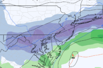
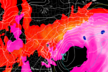
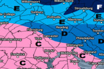
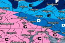
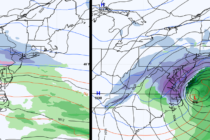
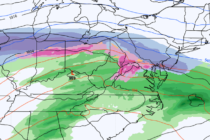
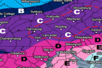
Discussion: I’m going to break this winter storm into three phases of expectations. Phase I: Precipitation is currently approaching from the W. It’s just now getting into the Kentucky/Indiana/Ohio area and starting to build the initial snow thump expected for

Read Full Article
Jan 29: Snow Storm a GO!

Jan 29: Snow Storm a GO!

🕔15:43, 29.Jan 2021

Discussion: I’m sorry but no map yet. There is still significant uncertainty as to where the exact jackpot axis of snowfall is going to set up through NJ and ultimately where the NW cutoff and SE snow/rain line will be.

Read Full Article
Jan 28: Winter Storm Chances Increasing

Jan 28: Winter Storm Chances Increasing

🕔23:06, 28.Jan 2021

Discussion: The coastal storm that missed us to the S (bringing a swath of snow through parts of NC/VA) has departed well into the Atlantic Ocean. The backside of this cyclonic flow has pulled down more cold from the available

Read Full Article
Jan 26: Active Pattern Continues

Jan 26: Active Pattern Continues

🕔15:16, 26.Jan 2021

Discussion: The weak wave has just about passed. Just another small batch of light precip is expected to move through NNJ later tonight and taper off by early Wednesday AM hours. The primary low involved in the generally weak transfer

Read Full Article
Jan 25: Light Wintry Event Approaching

Jan 25: Light Wintry Event Approaching

🕔15:21, 25.Jan 2021

Discussion: Precipitation just ahead of a warm front (currently over KY/WV/VA) is moving in from our SW. It should first move into SWNJ anytime after sundown tonight as snow and then try to spread into SENJ and maybe even CNJ

Read Full Article
Jan 24: Snow Update

Jan 24: Snow Update

🕔14:59, 24.Jan 2021

Discussion: This map and discussion might seem unnecessary for a minor snow event. But there will be multiple forms of wintry precipitation capable of impacting travel and safety this Monday night through most of Tuesday. With that said, let’s focus

Read Full Article
Jan 23: Tracking Two Wintry Systems

Jan 23: Tracking Two Wintry Systems

🕔15:11, 23.Jan 2021

Discussion: We currently have high pressure (anti-cyclonic flow) to our W and low pressure (cyclonic flow) to our E. This is producing a tight N to S pressure gradient (strong N/NW flow) and tapping Arctic air mass over Canada. For

Read Full Article
Jan 22: Winter Storm Detected

Jan 22: Winter Storm Detected

🕔15:27, 22.Jan 2021

Discussion: A shot of Arctic air will move in from the NW starting tonight and will linger until Sunday. This should keep most, if not all, of NJ below freezing during this period. NNJ elevations and maybe Pine Barrens down

Read Full Article
Colder Conditions (Jan 18-22)

Colder Conditions (Jan 18-22)

🕔14:53, 17.Jan 2021

Discussion: Tonight should start a prolonged colder pattern for NJ. Nothing record breaking, just colder. It should already feel colder today than the warm sector air mass we saw earlier this weekend. This week should behave like a V graph

Read Full Article
Mixed Conditions (Jan 15-17)

Mixed Conditions (Jan 15-17)

🕔15:18, 14.Jan 2021

Discussion: The most important feature of our current forecast is the disrupted Pacific jet plowing into the W US. We’re going to see a -EPO/-PNA setup start to take shape. This will allow ridging to occur near Alaska and extreme

Read Full Article