Watching Two Snow Events

Watching Two Snow Events

🕔15:09, 18.Jan 2022

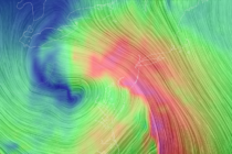
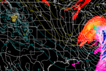
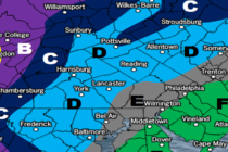
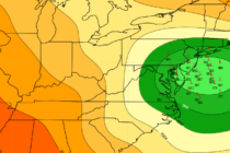
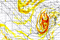
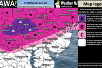
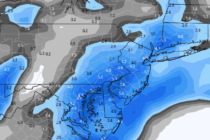
Discussion: Two snow events are on the table this week, one for Thursday and another for Saturday. Let’s break them down. Thursday looks like a generally light event. After a milder day in the 40s (Wednesday), rain should begin approaching

Read Full Article
Wintry Pattern Continues

Wintry Pattern Continues

🕔22:04, 17.Jan 2022

Discussion: Just wanted to thank you all for the support and kind words! The last few articles leading into the storm were actually picked up and aggregated by Google News. I look forward to more responsible discussion about weather safety,

Read Full Article
Strong Storm Approaching New Jersey

Strong Storm Approaching New Jersey

🕔15:02, 16.Jan 2022

Discussion: Earlier this week, a short wave dropped into the N US and dove to Texas to form a closed-off upper-level low (ULL). This ULL drifted E a bit, through the SE US, before interacting with another upper wave, that

Read Full Article
Strong New Jersey Storm Expected

Strong New Jersey Storm Expected

🕔15:40, 15.Jan 2022

Discussion: This upcoming Sunday PM-Monday AM event is not a pure snowstorm. It will contain some wintry aspects to it (upfront snow…possibly ending as snow for some) but the meat and potatoes of it are a strong synoptic-scale rain and

Read Full Article
Strong Storm Developing for New Jersey

Strong Storm Developing for New Jersey Updated

🕔16:40, 14.Jan 2022

Discussion: We’re still looking at a cold weekend. Current N/NW flow behind the departing ocean storm will pull Arctic air back over NJ tonight through early Sunday morning. It looks like no one will make it above freezing on Saturday

Read Full Article
Strong Storm to Impact New Jersey

Strong Storm to Impact New Jersey

🕔15:21, 13.Jan 2022

Discussion: A strong coastal low will be just offshore tomorrow (Friday). While nearly all model guidance suggests the precip to stay about 20-50 miles offshore, I just want to mention a small wildcard possibility of those precip bands making it

Read Full Article
Tracking the Sunday-Monday Storm Signal

Tracking the Sunday-Monday Storm Signal

🕔15:09, 12.Jan 2022

Discussion: The pattern, more favorable for winter storm development, is still expected to begin this Friday. I’m still only focused on the first few systems this Friday and Sunday-Monday but a very active pattern will continue afterwards to close out

Read Full Article
Cold Week. Wintry Pattern Emerges.

Cold Week. Wintry Pattern Emerges.

🕔15:05, 9.Jan 2022

Discussion: Much of the state eventually made it above freezing today with the warm front passage and warm sector. NWNJ elevations saw the worst of the freezing rain, as expected, and the precipitation will soon come to an end from

Read Full Article
Ice Approaching NNJ/NWNJ

Ice Approaching NNJ/NWNJ

🕔15:18, 8.Jan 2022

Discussion: Icy conditions are possible NW of the NJTP/I-95 corridor Sunday morning…after a cold overnight tonight directly under high pressure. A low pressure system pretty far N in Canada will team up with return flow behind the departing high and

Read Full Article
Wintry Pattern Setting In

Wintry Pattern Setting In

🕔20:24, 7.Jan 2022

Discussion: Real quick, tonight looks to remain cold, dry, and breezy/gusty out of the W/NW. Expect temperatures to bottom out in the teens/20s tomorrow (Saturday morning) just before sunrise. A high is approaching. We have the colder front-side flow of

Read Full Article