Light Snow Approaching/Developing
Discussion: The boundary, separating colder temps to the N and milder temps to the S is slowly pushing through NJ and should come to a rest just S/SE of NJ by later tonight. Temps should fall with sundown and the


Discussion: The boundary, separating colder temps to the N and milder temps to the S is slowly pushing through NJ and should come to a rest just S/SE of NJ by later tonight. Temps should fall with sundown and the

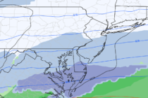
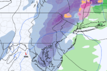
Discussion: The weather pattern for the next 7 or so days will be dominated by two features. One is a piece of the Tropospheric Polar Vortex (TPV). The other is a frontal boundary that will act as a storm track
Discussion: The weekend is rather straightforward. As of right now (Thursday afternoon) it’s still windy out of the W/NW behind the departing system that brought snow and rain to NJ on Wednesday. These winds should continue howling into Thursday night
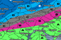
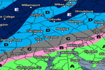
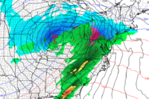
Discussion: There’s a tremendous amount of model disagreement with now less than 24 hours before the start of precipitation. Most of it revolves around how far SE the extent of snow will be in New Jersey. The overall consensus is
Discussion: This article will first cover the Wednesday-Thursday snow-to-rain event before we dive into some near-future signals I’m seeing. What we have been referring to as storm 1 arrived yesterday (as snow for NWNJ), precipitated overnight as mostly rain, and
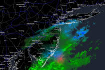
Discussion: The weak low associated with last night-this morning’s precipitation is now E of NJ. Winds have now become northerly for most of NJ and temperatures have dropped enough to return some areas that started wintry and changed to rain,
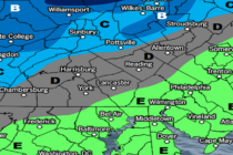
Discussion: A cold front passed through today but prior to peak afternoon solar heating. That allowed most of NJ to rise into the 40s even near-50. Temperatures and humidity will drop with sundown this evening and yield a colder Friday

Discussion: Some light rain is around today along a very weak front attached to a very weak low currently fizzling over the E Great Lakes. This is already on it’s way out and should clear for tonight’s overnight hours (Tuesday).

Discussion: First let’s talk about tonight. Temps should hold on the milder side and fail to dip below 45 or so. The primary low will generally track along/just NW of the Appalachian Mountains across parts of SE Ohio, W PA,
Discussion: Our weak wave has departed and we’ll now have fairly tranquil conditions through at least Thursday morning. A low pressure system is then expected to track from the central plains into the E Great Lakes area around Friday morning

LOCAL FORECAST | INTERACTIVE RADAR | LATEST NJ WEATHER ALERTS | WEDDING FORECAST| PRIVACY POLICY
© Copyright 2026 Weather NJ LLC. All Rights Reserved.
Some information that can be found on our website is provided by a private weather station and is not an officially recognized station for weather reporting. Though we always strive to achieve accurate reporting for our own use, it is important that you do NOT depend on the data provided here for any purpose.


