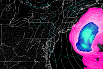
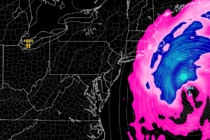
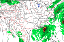
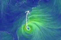
Back to homepage

Feature POST on Homepage

Unsettled into the Weekend

Unsettled into the Weekend

🕔15:14, 22.Mar 2023

Discussion: It looks like the upper-jet should push N of NJ from now through Saturday and establish a weak but unsettled E US ridge. High pressure, to the N of Bermuda, will track eastward today and tomorrow as a low

Read Full Article
Mixed Conditions Expected

Mixed Conditions Expected

🕔13:38, 17.Mar 2023

Discussion: The upper jet (250mb) should rage a bit, from SW to NE, over the Mid-Atlantic US this weekend. 500mb analysis indicates a deep upper-low tracking from the Great Lakes into SE Canada but in a very progressive trough with

Read Full Article
The “What Winter?” Sunsets

The “What Winter?” Sunsets

🕔15:49, 15.Mar 2023

Discussion: Of every 10 years, about 1-2 winters feature way-below average snowfall and in some cases a big goose egg. This winter was one of those. It was nice however to see parts of NNJ squeeze out some snow accumulation

Read Full Article
Final Call Heading into Tonight

Final Call Heading into Tonight Updated

🕔12:58, 13.Mar 2023

Discussion: After reviewing overnight mesoscale model guidance and comparing to live observations on SPC mesoscale analysis, we have the best idea we’re going to have heading into this system. This article and included snow impact map represents the final forecast

Read Full Article
Snow Map for Monday-Tuesday

Snow Map for Monday-Tuesday Updated

🕔16:58, 12.Mar 2023

Discussion: A powerful nor’easter continues to brew which will bring major impacts to New England, NE PA, E NY, and NNJ between Monday and Tuesday. I won’t talk much more about what this is going to do to E NY

Read Full Article
Major Snowfall Eyeing North Jersey

Major Snowfall Eyeing North Jersey

🕔16:41, 11.Mar 2023

Discussion: A full-blown nor’easter could heavily impact most of New England, E NY State, NE PA, and NNJ pretty hard this Monday-Tuesday. We’re talking major interior snow accumulation, blizzard wind and visibility conditions, and coastal battering and flooding. Tomorrow (Sunday)

Read Full Article
Snow Lover Nightmares Continue

Snow Lover Nightmares Continue

🕔14:32, 10.Mar 2023

Discussion: White rain is becoming the theme of tonight/tomorrow’s snow/rain event. The lower-level environment, especially the critical baroclinic boundary layer, is simply too marginal in the lower levels. March climatology, ground heat retention, and higher sun angle are likely going

Read Full Article
Weekend Snow Map

Weekend Snow Map

🕔12:54, 9.Mar 2023

Discussion: Our first system (Friday-Saturday) is now within line of sight to begin forecasting. Still some time to monitor the Monday-Tuesday system. With that said, let’s set some expectations. You are about to see two maps. The first map represents

Read Full Article
Winter Storm Detected for Friday-Saturday

Winter Storm Detected for Friday-Saturday

🕔16:22, 8.Mar 2023

Discussion: A winter storm is targeting NNJ with plowable snowfall this Friday PM-Saturday AM. A primary low will track along the N stream into NWPA by Friday night. Energy will then transfer to a secondary low spawning just off Delmarva/OBX

Read Full Article
Weekend Snow Detected

Weekend Snow Detected

🕔14:43, 7.Mar 2023

Discussion: Yesterday I was told by many that it couldn’t possibly snow in NNJ/CNJ last night because it was [insert temperature] degrees outside. Hopefully there is a better understanding now that “it is going to snow where it wants to

Read Full Article