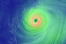
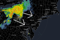
Back to homepage

Latest NJ Weather Alerts

Refreshing Conditions (Sept 16-20)

Refreshing Conditions (Sept 16-20)

🕔16:32, 15.Sep 2019

Discussion: Upper-level ridging should dominate the pattern this week. As the ridge slowly builds and approaches (Monday-Thursday) NJ should find itself under northerly 500mb flow. The warmest areas of the US this week should be closer to the Great Lakes,

Read Full Article
Weekend Outlook and Tropics Update

Weekend Outlook and Tropics Update

🕔18:41, 12.Sep 2019

Discussion: There’s three things I’d like to talk about: Tonight: Rain and thunderstorms will continue to push southward through the rest of NJ this evening. I expect them to clear the tip of SNJ by ~10pm. There’s an area of

Read Full Article
Warm Conditions Return (Sept 9-13)

Warm Conditions Return (Sept 9-13)

🕔21:31, 8.Sep 2019

Discussion: Hopefully everyone enjoyed the recent taste of fall behind Dorian’s departure. We’re about to be reminded that it’s still summer however. A few different areas of high pressure in the W Atlantic Ocean will pump a ridge over the

Read Full Article
Sept 6: Dorian Departs. Now what?

Sept 6: Dorian Departs. Now what?

🕔21:04, 6.Sep 2019

Discussion: Hurricane Dorian made landfall at Cape Hatteras, NC early this morning. There is some debate as to whether it was technically a landfall since the exact center of the eye might have missed land. But since Cape Hatteras went

Read Full Article
Spectacular Conditions After Dorian (Sept 6-8)

Spectacular Conditions After Dorian (Sept 6-8)

🕔20:26, 5.Sep 2019

Discussion: Dorian’s far-NW side should bring rain, wind and coastal flooding to at least SENJ on Friday and possibly further N and W into NJ. Winds should gradually pick up overnight tonight and everything should taper off and pull away

Read Full Article
Sept 5: Dorian Effects Approaching

Sept 5: Dorian Effects Approaching

🕔15:15, 5.Sep 2019

Discussion: The above image represents where Hurricane Dorian should be around 4pm Friday. Hurricane Dorian will not make landfall, or come anywhere near making landfall, on New Jersey. The far-NW side of Dorian’s cyclonic flow however is expected to bring

Read Full Article
Sept 4: Dorian NJ Impact Update

Sept 4: Dorian NJ Impact Update

🕔18:47, 4.Sep 2019

Discussion: Per the latest (5PM) National Hurricane Center update Dorian is still packing sustained winds of 110mph and is moving N/NW at 8mph with a central pressure of 961mb. Dorian is just off the coastal Jacksonville, FL/Savannah, GA area. In

Read Full Article
Sept 4: T-Storm Discussion for Tonight

Sept 4: T-Storm Discussion for Tonight

🕔12:55, 4.Sep 2019

Discussion: An upper-level 250mb jet on the N/NW side of the Bermuda high will couple with the dipping northern upper-level 250mb jet. This should produce a solid upper-level 250mb jet out of the SW over NJ tonight which has the

Read Full Article
Sept 2019 WeatherTrends360 Outlook

Sept 2019 WeatherTrends360 Outlook

🕔20:36, 3.Sep 2019

It’s time to harness WeatherTrends360 technology and look at how the rest of September 2019 should play out. WeatherTrends360 algorithms are documented with an 84% verification rate and are based on oceanic water cycles, time table series and very complex

Read Full Article
Sept 3: Dorian to Affect New Jersey

Sept 3: Dorian to Affect New Jersey

🕔19:14, 3.Sep 2019

Discussion: So that there is no confusion Dorian will NOT make landfall or even come close to making landfall on the New Jersey coast. This article is about how the far-NW side of the cyclone will affect New Jersey between

Read Full Article