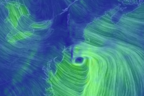
Back to homepage

Latest NJ Weather Alerts

Feb 17: Final Call For Weekend Snow

Feb 17: Final Call For Weekend Snow

🕔12:09, 17.Feb 2018

Click here to view full-resolution snow map! Discussion: We’ve made a few tweaks based on live observations and the latest guidance data. Temperatures dropped below freezing statewide early this morning as expected. Warm air advection however has already spread into

Read Full Article
Feb 16: Winter Storm Approaching

Feb 16: Winter Storm Approaching

🕔17:07, 16.Feb 2018

Click here for full-resolution impact map! Discussion: We’ve beaten this system to death now. It’s a weak wave traversing a frontal boundary that will first be pushed to our S overnight tonight and then brought back up into NJ tomorrow.

Read Full Article
Feb 15: First Call Weekend Snow Map

Feb 15: First Call Weekend Snow Map

🕔16:42, 15.Feb 2018

Click here for full-resolution impact map! Discussion: Not much has changed since last night’s article. We have a weak coastal low tracking close to SENJ. That’s going to put zone A and B in the most probable zone for a

Read Full Article
Feb 14: Watching Weekend Snow Potential

Feb 14: Watching Weekend Snow Potential

🕔20:46, 14.Feb 2018

Discussion: Passing scattered rain showers with isolated downpours are possible overnight tonight followed by a very mild Thursday into Friday. We’re talking highs into the 60s. More rain showers are expected Friday ahead of the cold front but then we drop.

Read Full Article
Mixed Conditions Expected (Feb 12-16)

Mixed Conditions Expected (Feb 12-16)

🕔18:34, 11.Feb 2018

Discussion: Our washout rain system is just about finished. A slow-to-exit boundary likely means more rainfall along and SE of I-95 through mid-to-late morning on Monday. After that we’re dry and relatively mild until about Thursday. Between Thursday and Friday

Read Full Article
Let it Wash Over You (Feb 9-11)

Let it Wash Over You (Feb 9-11)

🕔21:58, 8.Feb 2018

Discussion: A weak wave could scrape NNJ with flurries/snow showers Friday afternoon-evening but little-to-no accumulation is expected. Departing high pressure should then establish in the W Atlantic and re-enforce warmer southerly flow as a weak low tracks through NJ from

Read Full Article
Feb 6: Wednesday Final Call and Snow/Ice Maps

Feb 6: Wednesday Final Call and Snow/Ice Maps

🕔17:01, 6.Feb 2018

Click here for full-resolution snow map! Click here for full-resolution ice map! Discussion: A wintry disturbance is approaching from W/SW. If you draw a line from West Virginia through SEPA and NYC into the Boston area, that’s where the low

Read Full Article
February Discussion with WeatherTrends360

February Discussion with WeatherTrends360

🕔11:26, 6.Feb 2018

It’s time to harness the WeatherTrends360 proprietary weather algorithms to see how the rest of February 2018 should play out. But first lets break New Jersey into proper climatological regions. We have the higher elevations of NNJ/NWNJ, the interior coastal plain (SWNJ through CNJ

Read Full Article
Wednesday Snow Map and Outlook (Feb 6-9)

Wednesday Snow Map and Outlook (Feb 6-9)

🕔16:00, 5.Feb 2018

Click here for full-resolution impact map! Discussion: A weak area of low pressure should ride a frontal boundary through SEPA and the NYC area between Wednesday afternoon and evening. This should bring area-wide precipitation. Those along and NW of I-95

Read Full Article
Feb 3: Sunday Weather Impact Map

Feb 3: Sunday Weather Impact Map

🕔15:04, 3.Feb 2018

Click here to view full impact map! Discussion: Low pressure will drive into the E Great Lakes before transferring to a weak coastal low just offshore of SENJ. Warm sector flow ahead of the low pressure should keep most of

Read Full Article