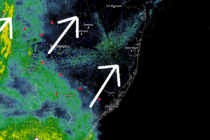
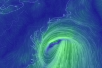
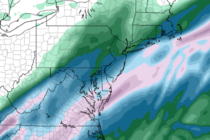
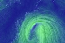
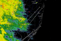
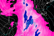
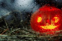
Back to homepage

Latest NJ Weather Alerts

March 5: Wednesday Snow Map

March 5: Wednesday Snow Map

🕔16:56, 5.Mar 2018

Click here for full-resolution snow map! Discussion: I know this map is busy so let me explain. The idea of jackpot accumulations occurring to the NW of I-95 is a fair assumption. That’s your most-likely Kaboom zone (zone A). The idea

Read Full Article
March 4: Winter Storm Detected

March 4: Winter Storm Detected

🕔20:31, 4.Mar 2018

Discussion: The blocking signal is still strong enough to impact approaching upper-level shortwaves coming in from Canada. A few shortwaves are expected to meander in from the W/NW in a “ring around the rosie” manner. Despite the incredible block, the approaching Pacific

Read Full Article
March Discussion with WeatherTrends360

March Discussion with WeatherTrends360

🕔17:34, 4.Mar 2018

It’s time to harness the WeatherTrends360 proprietary weather algorithms to see how the rest of March 2018 should play out. But first lets break New Jersey into climatological regions. We have the higher elevations of NNJ/NWNJ, the interior coastal plain (SWNJ through CNJ and

Read Full Article
Nor’easter Pulls Away (March 3-4)

Nor’easter Pulls Away (March 3-4)

🕔10:44, 3.Mar 2018

Discussion: The above modern satellite imagery shows the nor’easter pulling away from the E US. A tremendous mid-latitude cyclone! Southern coastal New England took the worst of it. New Jersey only dealt with secondary effects. NNJ elevations Kaboomed with snowfall

Read Full Article
March 2: Nor’easter Update

March 2: Nor’easter Update

🕔17:03, 2.Mar 2018

Discussion: The nor’easter has intensified to a 974mb low just S of Cape Cod. It is now taking small steps towards the NJ coast while ultimately moving S and away away to the S/SE towards Bermuda. Let’s take each weather condition at

Read Full Article
March 1: Dangerous Situation Unfolding

March 1: Dangerous Situation Unfolding

🕔16:59, 1.Mar 2018

Rain Map: Please click here for full-resolution rain map! Wind Map: Please click here for full-resolution wind map! Snow Map: Please click here for full-resolution snow map! Discussion: Two upper-level shortwaves will merge near the E Great Lakes area and form

Read Full Article
Feb 28: Strong Nor’easter Expected!

Feb 28: Strong Nor’easter Expected!

🕔17:00, 28.Feb 2018

Rain Map: Please click here for full-resolution rain map! Wind Map: Please click here for full-resolution wind map! Snow Map: Please click here for full-resolution snow map! Discussion: I’m finding it very difficult to get a handle on the coastal flooding

Read Full Article
Feb 26: Coastal Storm Detected

Feb 26: Coastal Storm Detected

🕔19:59, 26.Feb 2018

Discussion: I’ve been watching this tremendous blocking pattern evolve and unfold for a while now. There is no doubt it’s coming. As a quick refresher, blocking is represented by a negative-phased state of the North Atlantic Oscillation (NAO). It means

Read Full Article
Dry Start. Wet and Windy Finish (Feb 26-Mar 2)

Dry Start. Wet and Windy Finish (Feb 26-Mar 2)

🕔22:10, 25.Feb 2018

Discussion: Monday through Thursday AM is fairly straight-forward. Passing high pressure should have complete control of the region underneath a building ridge of upper-level heights. This means dry, sunny and relatively mild weather for NJ from Monday through Thursday morning.

Read Full Article
Wet Conditions Expected (Feb 23-25)

Wet Conditions Expected (Feb 23-25)

🕔19:31, 22.Feb 2018

Discussion: A near-stationary Bermuda high will allow multiple disturbances to rotate around its NW quadrant through NJ this weekend. This should produce on-and-off periods of rainfall through Sunday afternoon/evening. There’s a little concern for icing in the NNJ elevations on

Read Full Article