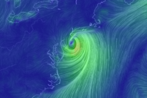
Back to homepage

Posts From Jonathan Carr

Dec 19: Rainstorm Approaching

Dec 19: Rainstorm Approaching

🕔18:36, 19.Dec 2018

Discussion: A shortwave that came off the Pacific (over California) will phase with a northern stream shortwave over the southern central US and depart over the Atlantic Ocean. The surface low of interest will form “miller-A” style out of the northern

Read Full Article
Cold Start. Mild Wet Finish (Dec 17-21)

Cold Start. Mild Wet Finish (Dec 17-21)

🕔11:13, 17.Dec 2018

Discussion: Upper-level low energy, that influenced the departing system from this weekend, is moving out to sea as well. A trailing upper-level shortwave will dive in and keep the first part of this week cold. The coldest bottom point looks

Read Full Article
Dec 15: Wintry Sunday Possible for NNJ

Dec 15: Wintry Sunday Possible for NNJ

🕔14:27, 15.Dec 2018

Discussion: As low pressure slides by to our S (from W to E)  high pressure is sliding by to our N (also from W to E). The low is drawing up the warmer moisture while the high is pushing down the

Read Full Article
Wet and Mild (Dec 14-16)

Wet and Mild (Dec 14-16)

🕔15:52, 13.Dec 2018

Discussion: Our upper-level disturbance is moving out and above-average 500mb height anomalies will fill the void. That is until another, but stronger, upper-level disturbance slides through to our S this weekend. At the surface this should mean a cloudy and

Read Full Article
Dec 12: Light Snow Approaching

Dec 12: Light Snow Approaching

🕔18:29, 12.Dec 2018

Discussion: Trends in the last 24 hours indicate a slightly northern track in the upper-level low and surface moisture beneath as well as earlier timing. The upper-level low looks to pass from W to E over the NY State/PA border and

Read Full Article
Dec 11: Sneaky Thursday PM Snow

Dec 11: Sneaky Thursday PM Snow

🕔15:04, 11.Dec 2018

Discussion: Every once in a while a sneaky light snow event comes out of nowhere. It might be from ocean-effect snow, a larger system trailing mid-level (700-850mb) disturbance, a strong lake-effect squall, etc. In the case of this Thursday PM it

Read Full Article
Cold Dry Week Ends Mild Wet (Dec 10-14)

Cold Dry Week Ends Mild Wet (Dec 10-14)

🕔10:59, 10.Dec 2018

Discussion: 500mb heights should remain below-average for much of this week. A trailing shortwave should reinforce the cold Tuesday night/Wednesday morning at the surface. We should then moderate for a likely-wet weekend. There’s cold air aloft and the ocean is

Read Full Article
Dec 6: Weekend Storm Update

Dec 6: Weekend Storm Update

🕔16:38, 6.Dec 2018

Discussion: This article will act as both the weekend outlook and winter storm discussion for the Sunday-Monday period.  A weak cold front will push through between tonight and early tomorrow morning. Aside from the start of colder weekend temperatures a few

Read Full Article
Dec 4: Let’s Talk Snow

Dec 4: Let’s Talk Snow

🕔16:42, 4.Dec 2018

Discussion: We have two opportunities for snow this week. I don’t need to tell you that colder air is in place and it will stay over the Mid-Atlantic US well into next week. The first opportunity will likely be a very

Read Full Article
Cold Dry Conditions Expected (Dec 3-7)

Cold Dry Conditions Expected (Dec 3-7)

🕔18:25, 2.Dec 2018

Discussion: Real quick: The Weather NJ mobile app is now live on Apple and Google …an early holiday gift to you all! The Dec 4-5th winter storm signal will be squashed way to the to the S of NJ by cold northerly

Read Full Article