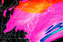
Back to homepage

Posts From Jonathan Carr

Winter Reloads (Jan 21-25)

Winter Reloads (Jan 21-25)

🕔19:38, 20.Jan 2019

Discussion: Temperatures will continue to drop overnight tonight until about sunrise tomorrow morning. Most of the state should range from single-digits to teens NNJ to SNJ but no reason why NNJ elevations can’t drop below zero. The gusty winds will

Read Full Article
Jan 19: Ice Storm Targets NNJ

Jan 19: Ice Storm Targets NNJ

🕔12:56, 19.Jan 2019

For full-resolution snow map please click here! For full-resolution ice map please click here! For full-resolution rain map please click here! Discussion: One final update on the forecast and then we’re ready to begin live observations. The storm is approaching from

Read Full Article
Jan 18: Snow Ice and Rain Storm Approaching

Jan 18: Snow Ice and Rain Storm Approaching Updated

🕔16:45, 18.Jan 2019

For full-resolution snow map please click here! For full-resolution ice map please click here! For full-resolution rain map please click here! Discussion: This storm system is very complex both in mesoscale components and change over duration of the event. It is

Read Full Article
Jan 17: Weekend Winter Storm Update

Jan 17: Weekend Winter Storm Update Updated

🕔16:45, 17.Jan 2019

For full-resolution snow map please click here! For full-resolution ice map please click here! For full-resolution rain map please click here! Discussion: The above winter storm impact maps are fairly self-explanatory. As far as pure snow goes only NJ areas N

Read Full Article
Jan 16: Winter Weather Update

Jan 16: Winter Weather Update

🕔17:16, 16.Jan 2019

Discussion: Just like this past weekend for SNJ, this first system is not that big of a deal. However, it doesn’t take much to present safety hazards especially when the morning rush hour commute is affected. The first system should start

Read Full Article
Jan 15: Snow Map for System One

Jan 15: Snow Map for System One

🕔16:23, 15.Jan 2019

Discussion: My main focus right now is on the first Thursday night-Friday morning system. This is an overall weak system that came onshore yesterday off the Pacific Ocean (onto California). From now until Thursday it should track from W to E

Read Full Article
Jan 14: The Tale of Two Systems

Jan 14: The Tale of Two Systems

🕔20:19, 14.Jan 2019

Discussion: While most of the focus is on the bigger weekend potential, we cannot drop our guard for a sneaky wave Thursday night into Friday morning. Energy is just coming off the Pacific Ocean onto California for this first system. The

Read Full Article
The Next Winter Storm Signal

The Next Winter Storm Signal

🕔14:16, 13.Jan 2019

Discussion: We have a lot to talk about. First, a final update and quick recap of this weekend’s winter storm. A few final bands of snow are still moving out of SNJ but have 1-2 hours left of impact. I expect

Read Full Article
Jan 11: Updated Weekend Snow Map

Jan 11: Updated Weekend Snow Map

🕔16:54, 11.Jan 2019

Discussion: Dynamics are leaning towards the heavier wildcard from yesterday’s discussion. It’s still not looking like a shut-down snow storm but it could mean a plowable event for a larger part of SNJ. We’re dealing with a fairly weak, but strong-enough,

Read Full Article
Jan 10: Light Snow Event Expected

Jan 10: Light Snow Event Expected

🕔17:50, 10.Jan 2019

Discussion: Low pressure will track across the SE US and eject into the Atlantic Ocean over OBX. From there it is not expected to turn up the coast and produce a major snow storm. Instead it will likely remain on

Read Full Article