Mild Conditions (Dec 11-13). But then…
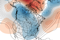
Discussion: The upper jet will make several meridional fluctuations over the next few weeks over NJ. This should allow a few low pressure systems to pass just to the SE of NJ from W to E—putting parts of NJ on


Discussion: The upper jet will make several meridional fluctuations over the next few weeks over NJ. This should allow a few low pressure systems to pass just to the SE of NJ from W to E—putting parts of NJ on
Discussion: I wanted to provide a longer-range outlook today after seeing a few things. The modeled teleconnections, on the Euro Ensembles, are indicating a much stronger -AO/-NAO pattern setting in. The values take a noticeable dive in the Dec 15-18

Discussion: We’re now under the NW flow that occurs in the upper levels on the back of a trough. A very weak upper-level disturbance, and associated surface low in Canada, is going to send a piece of the energy from

Discussion: Much of the state will drop below freezing tonight (Sunday night). The early weekend storm system for NJ went on to bring snow in parts of New England as a decent mid-latitude cyclone. The backside cyclonic flow of that

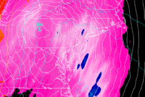
Discussion: Model guidance indicates a very meridional jet pattern over the next few weeks with ample below-average geopotential height anomalies. At the surface this means colder temperatures and an active pattern. Whether or not one of these systems times with
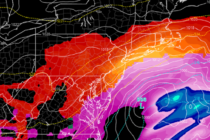
Discussion: In yesterday’s article we discussed how an Upper Level Low (ULL) in the interior SW US was handing a piece of energy off to the ULL over SE Canada/NE US. This expected transformation of cyclonic energy has not changed.
Discussion: The upper level low/trough that brought Monday’s storm and the current colder conditions is currently lingering over SE Canada and the NE US. There is also an upper level low in the interior SW US trapped under strong W
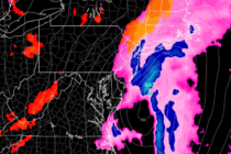
Discussion: The heaviest precipitation slug has passed through New Jersey from S/SW to N/NE. Some of those downpours were intense. I know because I was in one. Remaining precipitation today will be of an isolated-to-scattered nature, no longer widespread. We
Discussion: Two upper level disturbances, from separate N and S jet streams, are combining into a single energy vort to our W in the central US. I still see this as a pattern changer. The first of many surface lows

Discussion: A pattern change is still expected to begin with a stormy Monday (Nov 30). The upper levels will be very meridional with lower height anomalies dominating as far out as I can comfortably see (out to about Dec 10).

LOCAL FORECAST | INTERACTIVE RADAR | LATEST NJ WEATHER ALERTS | WEDDING FORECAST| PRIVACY POLICY
© Copyright 2026 Weather NJ LLC. All Rights Reserved.
Some information that can be found on our website is provided by a private weather station and is not an officially recognized station for weather reporting. Though we always strive to achieve accurate reporting for our own use, it is important that you do NOT depend on the data provided here for any purpose.


