Run-of-Mill Mid-Summer Conditions
Discussion: The upper jet is rather unremarkable for the next week or so. No major dips (troughs) or peaks (ridges). The only thing that jumps out at me is SW flow aloft from the decaying front of the trough leading


Discussion: The upper jet is rather unremarkable for the next week or so. No major dips (troughs) or peaks (ridges). The only thing that jumps out at me is SW flow aloft from the decaying front of the trough leading
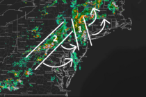
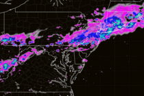
Discussion: We are looking at two parts to the main event that are already underway for NNJ (currently 3:50pm). These parts are attached to the low and will rotate through NJ as I have them illustrated in the above cover
Discussion: Some much needed New Jersey rainfall is looking promising for the next few days, especially Tuesday PM into Wednesday AM. For the last few months, most rainfall has occurred from frontal systems and training thunderstorms. This opportunity is more

Discussion: I apologize in advance how this post might contribute towards summer shore traffic, but it looks like one of the best mid-summer weekends I’ve ever seen. The cold front came through yesterday (Wednesday) and cleared a lot of humidity
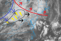
Discussion: The image above illustrates my best approximation of the warm front (red), cold front (blue) and today’s main cluster of thunderstorms (black). The warm front is almost through NJ (moving SW to NE). It just sparked a cell for
Discussion: Before we continue, I want to say that life-threatening/damaging winds from severe weather (straight-line or tornado) are a bad thing. I take my discussions very seriously when including such in my forecast, even if just a small, isolated threat
Discussion: I want to touch on yesterday (Thursday) before looking at tomorrow. As someone who spent almost 40 years of my life growing up in the Manahawkin area, I can only remember a few times where that much water fell

Discussion: Many NJ locations broke 90, if not are in the mid-to-upper 80s. Skies are hazy from the upstream wildfires and that should peak in-intensity tonight (Thursday) into tomorrow (Friday). The same type of linear segment of downpours/thunderstorms that happened

Discussion: A ridge will set up over the N Plains/N/S Dakota area this week. This will position upper flow over the Great Lakes and towards NJ and much of the N Mid-Atlantic US/New England. This pattern should stay locked until

Discussion: The upper levels are indicating changes in the future pattern. While the overall pattern keeps the jet stream N of NJ (inducing ridges), I am seeing a few periods where the jet stream wants to dip to near or

LOCAL FORECAST | INTERACTIVE RADAR | LATEST NJ WEATHER ALERTS | WEDDING FORECAST| PRIVACY POLICY
© Copyright 2026 Weather NJ LLC. All Rights Reserved.
Some information that can be found on our website is provided by a private weather station and is not an officially recognized station for weather reporting. Though we always strive to achieve accurate reporting for our own use, it is important that you do NOT depend on the data provided here for any purpose.


