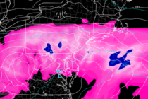
Back to homepage

Latest NJ Weather Alerts

Unsettled Start. Beautiful Finish (May 29-31)

Unsettled Start. Beautiful Finish (May 29-31)

🕔21:33, 28.May 2020

Discussion: A NW upper jet should be nearby NJ for the foreseeable near future. We’re going to build a trough slowly between Saturday and Sunday which should flex Sunday-Tuesday before heights rise Wednesday-forward. High pressure has remained nearly stationary the

Read Full Article
Warmer Conditions Expected (May 26-29)

Warmer Conditions Expected (May 26-29)

🕔15:39, 25.May 2020

Discussion: Happy Memorial Day everyone! A moment of silence, appreciation and gratitude to those who have fallen to protect our amazing way of life… The upper-jet should stay to the N of NJ through at least Friday. This will correlate

Read Full Article
Memorial Day Weekend Outlook

Memorial Day Weekend Outlook

🕔23:04, 21.May 2020

Discussion: We currently have an upper level low over KY/TN weakening as it is colliding with strong ridging over SE Canada/NE US. It if fizzled out completely we would not have a worry about nuisance precipitation Friday-Saturday. But it does

Read Full Article
Unsettled Conditions (May 18-22)

Unsettled Conditions (May 18-22)

🕔16:14, 17.May 2020

Discussion: Rough ocean conditions should have the headline this week despite much better conditions inland and away from water. The upper jet should stay way to the N of NJ this week. Normally this would produce a heat wave sea

Read Full Article
The Warm Season Begins (May 15-17)

The Warm Season Begins (May 15-17)

🕔11:18, 14.May 2020

Discussion: Some passing isolated showers later today/tonight but no big deal. The warm season has begun! The weekend looks pretty good Friday through Sunday AM however there is lots to discuss. Upper-level 250mb analysis indicates the jet staying to the

Read Full Article
The Good Stuff is Coming (May 11-15)

The Good Stuff is Coming (May 11-15)

🕔12:08, 11.May 2020

Discussion: The upper-jet is now over NJ and will eventually move N of NJ by Thursday with a correlating air mass of above-average 500mb geopotential height anomalies (ridging) over NJ. That warmer upper-level pattern then looks to sustain for the

Read Full Article
Snow? (May 8-10)

Snow? (May 8-10)

🕔15:28, 7.May 2020

Discussion: Upper-level analysis indicates the jet staying S of NJ this weekend in the continued-E US trough pattern with abnormally low 500mb geopotential height anomalies. If this was winter the snow lovers would be excited. But it’s not. The sun

Read Full Article
Cool and Unsettled (May 4-8)

Cool and Unsettled (May 4-8)

🕔11:46, 3.May 2020

Discussion: I’ve seen happier outlooks for the Mid-Atlantic and NorthEast US before. 250mb and 500mb analysis indicates the upper-jet staying over or S of NJ with prolonged upper-level troughing as far as I can comfortably see. This means below-average temperatures

Read Full Article
May 2020 Outlook

May 2020 Outlook

🕔11:06, 3.May 2020

It’s time to harness WeatherTrends360 technology and look at how the rest of May 2020 should play out. WeatherTrends360 algorithms are documented with an 84% verification rate and are based on oceanic water cycles, time table series and very complex

Read Full Article
Conditions Improve (May 1-3)

Conditions Improve (May 1-3)

🕔12:18, 1.May 2020

Discussion: Low pressure has passed through and will now track towards the Maine/SE Canada region. We’re left on the back-side of cyclonic flow with enough nearby lifting, from the departing low, to spark a few showers and even t-storms today.

Read Full Article