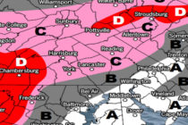
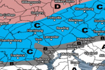
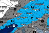
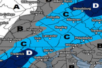
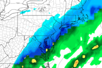
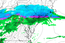
Back to homepage

Feature POST on Homepage

Great Start. Unsettled Finish (May 25-28)

Great Start. Unsettled Finish (May 25-28)

🕔19:42, 24.May 2018

Discussion: The high pressure responsible for the spectacular weather today and tomorrow (Friday) will slide out into the ocean by Saturday. This will generate return flow which should pump higher humidity into the equation for Saturday. For this reason, all

Read Full Article
Conditions Improve (May 21-25)

Conditions Improve (May 21-25)

🕔13:35, 21.May 2018

Discussion: The only disruptive weather I see this week is Tuesday during PM hours. A cold front should push some rain and possibly thunderstorms through the region. Thunderstorm intensity will be determined by diurnal heating capability during the day on

Read Full Article
Unsettled Conditions Continue (May 18-20)

Unsettled Conditions Continue (May 18-20)

🕔13:22, 18.May 2018

Discussion: The Bermuda high remains stubbornly parked which should keep the return flow up the east coast in place. This should produce a wet Friday (today) and Saturday (tomorrow). Not all day washouts but certainly periods of outdoor cancelling rainfall/storms.

Read Full Article
May 15: Thunderstorms Approaching!

May 15: Thunderstorms Approaching!

🕔16:43, 15.May 2018

Discussion: The line of severe thunderstorms is currently pushing through EPA towards NJ. NWNJ is already up at bat with the rest of NJ on deck. This line should continue it’s NW to SE movement over the next 3-5 hours

Read Full Article
May 14: More Thunderstorms Detected

May 14: More Thunderstorms Detected

🕔19:30, 14.May 2018

For full-resolution storm map, please click here! Discussion: A Mesoscale Convective System (MCS) is currently pushing SW through Virginia and Maryland. It should further impact the Delmarva Peninsula over the next few hours. If certain criteria is met then it will

Read Full Article
Unsettled Conditions Continue (May 14-18)

Unsettled Conditions Continue (May 14-18)

🕔19:32, 13.May 2018

Discussion: The 250mb jet is modeled very zonal this week to the N of NJ. Not much to comment on at 500mb either aside from a prolonged period of above-average height anomalies. Most shortwaves hang in the W US. The

Read Full Article
Weatherboy Lawsuit Update

Weatherboy Lawsuit Update

🕔16:43, 12.May 2018

The following link will take you to a PDF file containing the motion for summary judgement as-filed by my attorneys in the US District Court of New Jersey yesterday (May 11, 2018). Parts of the filing are redacted due to the

Read Full Article
May 11: Thunderstorm Outbreak Detected

May 11: Thunderstorm Outbreak Detected

🕔20:18, 11.May 2018

Discussion: A warm front will push through from our SW to NE overnight. This should bring periods of rainfall and embedded thunderstorms across New Jersey between midnight and mid-to-late morning. A break is then expected until late-afternoon/early-evening. At some point

Read Full Article
Unsettled Conditions Expected (May 11-13)

Unsettled Conditions Expected (May 11-13)

🕔16:07, 10.May 2018

Discussion: That’s my mom and I in the photo in case you didn’t know. A happy mother’s day weekend to her and to all the moms out there! Once again a long-range weekend forecast has deteriorated in the short-to-mid-term forecasting

Read Full Article
Beautiful Week Expected (May 7-11)

Beautiful Week Expected (May 7-11)

🕔21:38, 6.May 2018

Discussion: A strung out area of coastal low pressure will linger to start the week. This should present the coast with a light onshore cooling mechanism while most of interior NJ achieves higher temperatures. Once that low pressure influence moves

Read Full Article