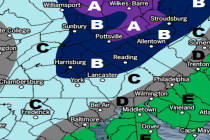
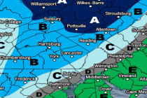
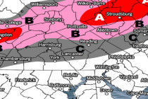
Back to homepage

Latest NJ Weather Alerts

July 2017 Discussion

July 2017 Discussion

🕔10:36, 3.Jul 2017

It’s time to harness the WeatherTrends360 proprietary weather algorithms to see how the rest of July 2017 should play out. But first lets break New Jersey into proper climatological regions. We have the higher elevations of NNJ/NWNJ, the interior coastal plain (SWNJ through CNJ and

Read Full Article
Monday-Friday Outlook (July 3-7)

Monday-Friday Outlook (July 3-7)

🕔10:18, 3.Jul 2017

Conditions this week are looking pretty run-of-mill for summer. Let’s break it down… Discussion: A strong ridge should eventually develop in the W US. This should prevent the E US from scorching above average this week. We might even fall

Read Full Article
Warm Humid Weather Expected (June 30-July 2)

Warm Humid Weather Expected (June 30-July 2)

🕔08:50, 30.Jun 2017

Unsettled, warm and sticky conditions give way to improvement by Sunday. Let’s break it down… Discussion: 250mb winds remain well to our N as the jet stream holds an area of higher 500mb heights over our region. It should stay this

Read Full Article
Mostly Nice Conditions Expected (June 26-30)

Mostly Nice Conditions Expected (June 26-30)

🕔22:23, 25.Jun 2017

This week looks pretty good but with a few things worth noting. Let’s break it down… Discussion: High pressure should have control of the region however 500mb heights should be below average to start the week. While this means no

Read Full Article
Wet Start Beautiful Finish (June 23-25)

Wet Start Beautiful Finish (June 23-25)

🕔21:33, 22.Jun 2017

Most of the weekend looks good aside from Cindy’s remnants. Let’s break it down… Discussion: The entire weekend forecast revolves around Cindy’s remnants which will be absorbed into an approaching upper-level longwave trough and pushed through the east coast between now and Saturday

Read Full Article
June 19: Thunderstorm Schedule

June 19: Thunderstorm Schedule

🕔11:55, 19.Jun 2017

The severe thunderstorm potential has not backed down. Here’s what to expect today… Please click here to view full resolution storm impact map. Discussion: More than adequate instability and sufficient wind shear parameters coupled with soupy dew points and a cold

Read Full Article
Stormy Start (June 19-23)

Stormy Start (June 19-23)

🕔23:24, 18.Jun 2017

Monday’s thunderstorm threat has the headline this week. Let’s break it down… Discussion: The severe thunderstorm threat remains firmly in place for Monday as a cold front is expected to plow through this haunting humid air mass. We have more

Read Full Article
June 17: Possible Thunderstorms Detected

June 17: Possible Thunderstorms Detected

🕔11:20, 17.Jun 2017

The Monday thunderstorm threat is increasing. Let’s break it down… Discussion: A cold front is expected to push through on Monday from W to E. Right now it looks like the frontal passage will occur Monday night into Tuesday morning with

Read Full Article
Warm Unsettled Weekend Expected (June 16-18)

Warm Unsettled Weekend Expected (June 16-18)

🕔10:55, 16.Jun 2017

By no means a washout but certainly a few unsettled periods. Let’s break it down… Discussion: A warm front has pushed through hence the southerly flow of warm/moist air. Convergence over the E US, from departing anti-cyclonic high pressure flow

Read Full Article
Hot Start Comfortable Finish (June 12-16)

Hot Start Comfortable Finish (June 12-16)

🕔11:08, 12.Jun 2017

After a hazy, hot and humid start, we moderate some. Let’s break it down… Discussion: The 250mb jet guidance indicates that the strongest stream winds will remain to our N this week. At 500mb, above-average height anomalies look to hang

Read Full Article