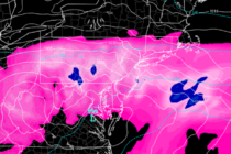
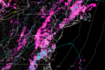
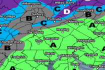
Back to homepage

Feature POST on Homepage

Mild Spring Conditions (April 6-10)

Mild Spring Conditions (April 6-10)

🕔14:41, 5.Apr 2020

Discussion: The upper-jet looks to stay near/overhead of NJ this week in a zonal configuration. The jet will slowly build intensity and likely flex into a decent streak by Thursday-Friday. 500mb geopotential height anomalies should be near-average for the start

Read Full Article
Turning Milder (April 3-5)

Turning Milder (April 3-5)

🕔16:48, 2.Apr 2020

Discussion: The upper jet is split with the primary streak to our S and a weaker dissolving streak to our N. The N part is powered by the backside (W side) of the departing upper-level low and front side (E

Read Full Article
April 2020 Outlook

April 2020 Outlook

🕔12:24, 2.Apr 2020

It’s time to harness WeatherTrends360 technology and look at how the rest of April 2020 should play out. WeatherTrends360 algorithms are documented with an 84% verification rate and are based on oceanic water cycles, time table series and very complex

Read Full Article
Cooler Conditions (March 31-April 3)

Cooler Conditions (March 31-April 3)

🕔16:06, 30.Mar 2020

Discussion: The upper-jet should remain mostly zonal through Wednesday before dipping S of NJ Thursday into Friday. After that, high pressure backs in from the NE and decently splits the jet to our N and S. Nothing exciting to speak

Read Full Article
Unsettled Conditions (March 27-29)

Unsettled Conditions (March 27-29)

🕔10:36, 27.Mar 2020

Discussion: The upper-jet should stay to the N of NJ this weekend before sinking over/just S of NJ by mid next week. 500mb height anomalies should be positive for this weekend correlating with the jet-formed ridge before lowering for next

Read Full Article
Raw Start. Mild Finish (March 23-27)

Raw Start. Mild Finish (March 23-27)

🕔16:34, 22.Mar 2020

Discussion: For the most part we’ll see a zonal jet pattern overhead this week before pushing a little to our N by the weekend. 500mb geopotential heights should remain elevated aside from two shortwaves Monday and Wednesday with very little

Read Full Article
Mild Start. Cooler Finish (March 20-22)

Mild Start. Cooler Finish (March 20-22)

🕔17:14, 19.Mar 2020

Discussion: The upper-level jet should push to the N of NJ on Friday as 500mb ridging flexes. The jet should then sink to the S of NJ for the rest of the weekend as geopotential heights relax but still remain

Read Full Article
Cool and Dry (March 13-15)

Cool and Dry (March 13-15)

🕔11:56, 13.Mar 2020

Discussion: A strong zonal upper-level jet will dominate the 250mb space over NJ this weekend. 500mb geopotential height anomalies will remain positive with a weak upper-level trough moving through SE Canada. There will be a strong surface low under that

Read Full Article
Will Warmer NJ Weather Slow the Spread of Coronavirus?

Will Warmer NJ Weather Slow the Spread of Coronavirus?

🕔16:47, 9.Mar 2020

We’re seeing a lot of conflicting information and fear mongering in the media about the COVID-19 coronavirus. This article is intended to inform our readers of facts and provide an educated response to questions we’ve received regarding weather and its

Read Full Article
Cold Wet Start. Mild Sunny Finish (March 6-8)

Cold Wet Start. Mild Sunny Finish (March 6-8)

🕔15:47, 5.Mar 2020

Discussion: A very dynamic upper-level interaction should occur between an incoming transient trough and a southern stream shortwave this Friday-Sat AM. Right now the southern energy is expected to race ahead of the trough on Friday bringing warmer rain and

Read Full Article