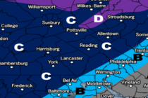
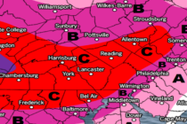
Back to homepage

Feature POST on Homepage

Cold Wet Start. Mild Sunny Finish (March 6-8)

Cold Wet Start. Mild Sunny Finish (March 6-8)

🕔15:47, 5.Mar 2020

Discussion: A very dynamic upper-level interaction should occur between an incoming transient trough and a southern stream shortwave this Friday-Sat AM. Right now the southern energy is expected to race ahead of the trough on Friday bringing warmer rain and

Read Full Article
March 2020 Outlook

March 2020 Outlook

🕔15:25, 2.Mar 2020

It’s time to harness WeatherTrends360 technology and look at how the rest of March 2020 should play out. WeatherTrends360 algorithms are documented with an 84% verification rate and are based on oceanic water cycles, time table series and very complex

Read Full Article
Spring is in the Air (March 2-6)

Spring is in the Air (March 2-6)

🕔15:58, 1.Mar 2020

Discussion: The Mid-Atlantic US should be dominated by converging upper-level jets in a progressive and zonal pattern through at least Thursday this week. We’ll then see a dip in the upper-level jet for Friday-Saturday which will naturally form an upper-level

Read Full Article
Dry and Colder (Feb 28-Mar 1)

Dry and Colder (Feb 28-Mar 1)

🕔10:54, 28.Feb 2020

Discussion: The 250mb jets (Polar and Pacific) are converging to the SW of NJ and keeping the overall jet pattern S of NJ this weekend. The jet should rise back over and N of NJ by Tuesday followed by a

Read Full Article
Unsettled Conditions (Feb 24-28)

Unsettled Conditions (Feb 24-28)

🕔13:12, 24.Feb 2020

Discussion: The upper-level (250mb) jet looks very aggressive over the Mid-Atlantic and NorthEast US this Wednesday overnight into Thursday morning. I see a strong jet streak with ample divergence and difluence aloft. This was the signal I mentioned last week.

Read Full Article
Cold Start. Mild Finish (Feb 20-23)

Cold Start. Mild Finish (Feb 20-23)

🕔14:22, 19.Feb 2020

Discussion: Another very positive-tilted upper-level trough will swing through over the next few days before giving way back to above-average geopotential heights Saturday into the first half of next week. That should put NJ inside the trough tonight through tomorrow

Read Full Article
Colder Conditions Moderate (Feb 14-16)

Colder Conditions Moderate (Feb 14-16)

🕔08:42, 14.Feb 2020

Discussion: A positive-tilted and progressive trough is currently swinging through the region and should give way to the front side of a ridge with upper-level NW flow. This is responsible for bringing the colder conditions that started last night (Thursday)

Read Full Article
Unsettled Start Cold Finish (Feb 10-14)

Unsettled Start Cold Finish (Feb 10-14)

🕔20:58, 9.Feb 2020

Discussion: Real quick, some precipitation is moving through tonight. Extreme NNJ could see some wintry precipitation type from this. It should move out by tomorrow morning. E US ridging and a Bermuda high should keep temperatures above average through Wednesday.

Read Full Article
Mild and Stormy to Colder and Unsettled (Feb 7-9)

Mild and Stormy to Colder and Unsettled (Feb 7-9)

🕔18:00, 6.Feb 2020

Discussion: The next and more significant precipitation slug moves through between tonight and about 6am tomorrow morning. SENJ should receive more rainfall than NWNJ but everyone’s on the hook for widespread periods of moderate, sometimes heavy, rain overnight tonight. Precipitation

Read Full Article
Feb 5: NNJ Ice Storm Update

Feb 5: NNJ Ice Storm Update

🕔16:18, 5.Feb 2020

Discussion: It’s been a somewhat colder day than the past few. The boundary has been pulled southward over NNJ from the back-side cyclonic flow of the weak wave that just departed. NNJ is already down into the 30s and some

Read Full Article