Warmup Coming
Discussion: High pressure should control most of the weekend as it tracks from the Northern-Central US through the Mid-Atlantic US. Friday will be the coldest day with N winds in front of the high. Saturday a step-up day as winds


Discussion: High pressure should control most of the weekend as it tracks from the Northern-Central US through the Mid-Atlantic US. Friday will be the coldest day with N winds in front of the high. Saturday a step-up day as winds

Discussion: A few weak N stream waves will track to our N this week with precipitation dissolving pretty much overhead. I suppose anything from flurries to snow showers are possible before it vanishes completely but it would need to fall
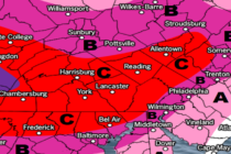
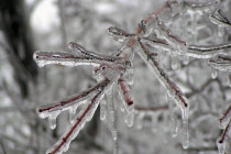
Discussion: A winter storm is brewing for New Jersey but snow accumulations are not the headline. Parts of NNJ might see some snow to start but the primary safety concern is ice in the form of sleet and/or freezing rain.
Discussion: Models are gaining confidence on the idea of the W US trough weakening and tracking E through the Great Lakes/New England regions between Wednesday and Saturday. This would create an environment for a weak and flat surface low to

Discussion: The upper level jet will stay to the N of NJ for most of this week with the Mid-Atlantic US under positive 500mb height anomalies. That’s a recipe for above-average temperatures and we’ll stay mild through Wednesday. I hope
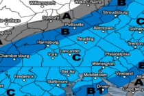
Discussion: A shallow trough will pass through the Mid-Atlantic and NorthEast US this weekend. An associated surface low will track through SE Canada and extend a cold front southward into the US. This could front should pass through NJ Saturday

Discussion: Ok all small human beings need to listen up. Thursday into Friday could be a rough night wind-wise. Let’s break it down into phases: Phase I: The Warm Sector Rip – NJ will be in the warm sector for

Discussion: Most are down into the single digits and teens already tonight. High pressure is moving through and clear skies/lighter winds will allow radiational cooling to do it’s thing. Tuesday and Tuesday night will be slightly milder than Monday but
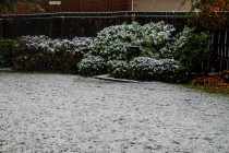
Discussion: Today was the last of the warmer afternoon-spiking days. A cold front will pass through overnight which will drop temperatures below freezing for many heading into the light snow event. The data has trended a bit for the approaching

Discussion: This system has been beaten to death for almost 7 days now. While appearing much stronger at times on long-range model guidance, it remains modeled very weak and light over the past few days. The cyclonic vorticity never evolved

LOCAL FORECAST | INTERACTIVE RADAR | LATEST NJ WEATHER ALERTS | WEDDING FORECAST| PRIVACY POLICY
© Copyright 2026 Weather NJ LLC. All Rights Reserved.
Some information that can be found on our website is provided by a private weather station and is not an officially recognized station for weather reporting. Though we always strive to achieve accurate reporting for our own use, it is important that you do NOT depend on the data provided here for any purpose.


