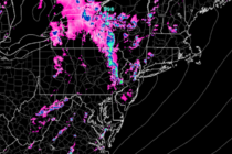
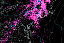
Back to homepage

Feature POST on Homepage

Snow? (May 8-10)

Snow? (May 8-10)

🕔15:28, 7.May 2020

Discussion: Upper-level analysis indicates the jet staying S of NJ this weekend in the continued-E US trough pattern with abnormally low 500mb geopotential height anomalies. If this was winter the snow lovers would be excited. But it’s not. The sun

Read Full Article
Cool and Unsettled (May 4-8)

Cool and Unsettled (May 4-8)

🕔11:46, 3.May 2020

Discussion: I’ve seen happier outlooks for the Mid-Atlantic and NorthEast US before. 250mb and 500mb analysis indicates the upper-jet staying over or S of NJ with prolonged upper-level troughing as far as I can comfortably see. This means below-average temperatures

Read Full Article
May 2020 Outlook

May 2020 Outlook

🕔11:06, 3.May 2020

It’s time to harness WeatherTrends360 technology and look at how the rest of May 2020 should play out. WeatherTrends360 algorithms are documented with an 84% verification rate and are based on oceanic water cycles, time table series and very complex

Read Full Article
Conditions Improve (May 1-3)

Conditions Improve (May 1-3)

🕔12:18, 1.May 2020

Discussion: Low pressure has passed through and will now track towards the Maine/SE Canada region. We’re left on the back-side of cyclonic flow with enough nearby lifting, from the departing low, to spark a few showers and even t-storms today.

Read Full Article
April 29: Heavy Rain & Strong Wind Approaching

April 29: Heavy Rain & Strong Wind Approaching

🕔16:54, 29.Apr 2020

Discussion: Another weather system featuring powerful upper-level dynamics should impact New Jersey tonight through Friday morning. Let’s break it down from top to bottom. 250mb jet analysis indicates a strong southerly jet streak for the E US coast on Thursday

Read Full Article
Unsettled Conditions (April 27-May 1)

Unsettled Conditions (April 27-May 1)

🕔14:16, 26.Apr 2020

Discussion: There will be no major synoptic storms this week despite the active and meridional look to the upper-level jet and 500mb height anomalies. At the surface we currently (Sunday) have a slow moving and weak low pressure system tracking

Read Full Article
Unsettled Conditions (April 24-26)

Unsettled Conditions (April 24-26)

🕔15:07, 23.Apr 2020

Discussion: The upper-level jet should stay to the S of NJ this weekend with a trough of below-average geopotential height anomalies overhead. This should keep NJ and surrounding areas very unsettled with colder air aloft over a milder surface temperature

Read Full Article
Mixed Conditions (April 20-24)

Mixed Conditions (April 20-24)

🕔15:19, 19.Apr 2020

Discussion: A very active pattern is likely for the next week or so. The upper-levels should see multiple shortwaves and troughs for the Mid-Atlantic US. At the surface the first disturbance is Monday. A low will eject near OBX and

Read Full Article
Unsettled Start. Mild Finish (April 17-19)

Unsettled Start. Mild Finish (April 17-19)

🕔09:54, 17.Apr 2020

Discussion: Not much to speak of in the upper levels. A zonal jet pattern overhead with slightly negative geopotential height anomalies. We have a weak disturbance tracking through the N Mid-Atlantic US. It should move in tonight (Friday) and clear

Read Full Article
Rough Start (April 13-17)

Rough Start (April 13-17)

🕔17:39, 12.Apr 2020

Discussion: This week is all about the damaging wind potential on Monday. After that it’s boring. Slightly cooler than we’d all like for this time of year but uneventful as the below daily forecast indicates. So let’s talk about Monday.

Read Full Article